Barwon South West
Regional Overview of the 2022-23 fire season
Conditions for autumn burning were heavily influenced by the prolonged La Niña conditions over the previous years and average rainfall over the summer of 2022–23.
This resulted in the Otways coming into autumn slightly wetter than average, whereas the Far South West district was slightly drier than average.
These background moisture conditions are reflected in reduced treated area numbers for the Otway Fire District (2,530 hectares) and Far South West Fire District (1,340 hectares) compared to the previous season (13,503 and 5,646 hectares respectively).
A strong feature of the autumn period was the short burning windows with the absence of long periods of stable weather. These weather features contributed to 3 burns along the Surf Coast proving challenging to manage in mid-March 2023 as weather conditions deteriorated after ignition had occurred.
These 3 burns were ultimately declared as bushfires, and although none escaped their boundaries the impact of the incident on local communities was considerable – particularly for parts of the Kennett River community.
Continued winter burning was a feature in both districts. This provided opportunities for Traditional Owner burning as well as ecological burns in heathy fuels.
This proactive use of burning windows continues to be a point of growth in Barwon South West (BSW) with annual planning and delivery of Landscape Mosaic Burning (LMB) operations continuing to evolve.
This evolution extends to monitoring with bespoke LMB monitoring methods currently being trialled in the Otways.
Fuel management delivery
The positive trends in fuel-driven bushfire risk reduction and ecosystem resilience in the BSW Region reflect carefully considered bushfire management strategies – including ecological burning.
The strategies aim to minimise both fuel-driven bushfire risk and the impacts of fuel management activities on ecosystem resilience.
During 2022–23, the BSW Region’s fuel management program focussed on planned burning, treating 3,854 hectares with planned burning and non-burn fuel treatment. FFMVic delivered 14 cross-tenure burns with the CFA.
Of the total hectares treated with fire, 20% were ecological burns.
The number of non-burn fuel treatments was more than double the number of planned burn treatments, with slashing or mowing being used for the majority of individual works.
However, while spraying was only used for 2 treatments, this method of fuel management treated 30% of all hectares treated by non-burn fuel works. The total cost of the BSW Region fuel management program in 2022–23 was $10.8 million.
Table 23 summarises the BSW Region’s fuel management activities in 2022–23.
Table 23: Fuel management activities, Barwon South West region, 2022–23.
| Fuel reduction | Total Hectares | Number of treatments |
|---|---|---|
| Area treated by planned burning | 3,854 | 29 |
| Ecological burns | 694 | 8 |
| Risk reduction burns | 3,160 | 20 |
| Windrow/heap burns | 1 | 1 |
| Area treated by non-burn fuel treatments | 839 | 73 |
| Mechanical mulching | 1 | 1 |
| Mechanical slashing or mowing | 591 | 70 |
| Other methods | 248 | 2 |
| Total area treated to reduce fuel-driven bushfire risk | 4,693 | 102 |
Of the fuel reduction burns conducted across the region, 83% were in APZ and BMZ and 17% in LMZ. All of the APZ burns were in the Otway District, aimed at protecting life and property.
Table 24: Fuel reduction by fire management zone, Barwon South West region, 2022–23.
Fire management zone | ||||
|---|---|---|---|---|
| APZ | BMZ | LMZ | Total | |
| Barwon South West Region | 1,273 hectares (9 burns) | 1,943 hectares (8 burns) | 638 hectares (12 burns) | 3,854 hectares (29 burns) |
| Far South West District | 0 hectares (0 burns) | 1,208 hectares ( 3 burns) | 130 hectares (8 burns) | 1,338 hectares (11 burns) |
| Otway District | 1,273 hectares (9 burns) | 735 hectares (5 burns) | 508 hectares (4 burns) | 2,516 hectares (18 burns) |
Fuel-driven bushfire risk
Barwon South West’s long-term regional planning target is to maintain fuel-driven bushfire risk at or below 60% of maximum levels. Districts also have long-term planning targets for the management of fuel-driven bushfire risk which assist FFMVic in meeting the statewide target and long-term regional planning targets.
Table 25 indicates the current level of fuel-driven bushfire risk in the region and how it has changed over the past 3 years.
Fuel-driven bushfire risk in Barwon's South West region remains below the long-term regional planning target at 58%.
Table 25: Fuel-driven bushfire risk, Barwon South West region and districts, 2022–23 and previously reported.
| Fuel-driven bushfire risk | 2020-21 | 2021-22 | 2022-23 |
|---|---|---|---|
| Barwon South West Region (Target 60%) | 61% | 58% | 58% |
| Far South West District (Target 55%) | 52% | 50% | 51% |
| Otway District (Target 60%) | 62% | 58% | 59% |
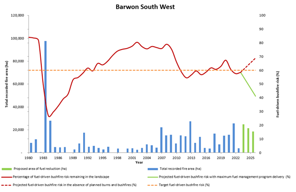
Figure 8 indicates the Barwon South West region’s risk profile for 1980 to 2023 and projected changes in fuel-driven bushfire risk until 2026.
It indicates fuel-driven bushfire risk in the Barwon South West region:
- is projected to increase to 69% by 2026 in the absence of any fuel management activity or bushfires
- implementing the entire JFMP would keep risk levels below the long-term regional planning target of 60%.
Figure 8: Barwon South West’s fuel-driven bushfire risk from 1980 – 2023. Data aligns with financial year
Ecosystem resilience
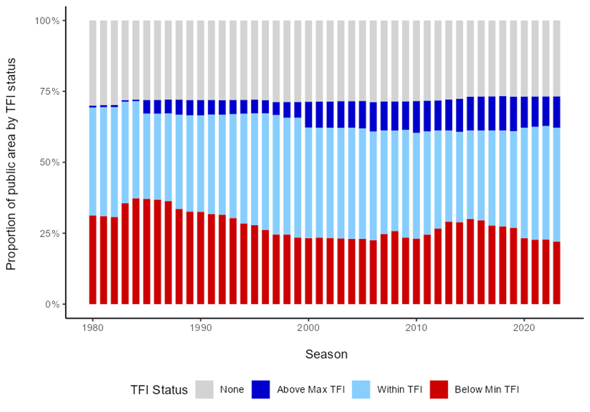
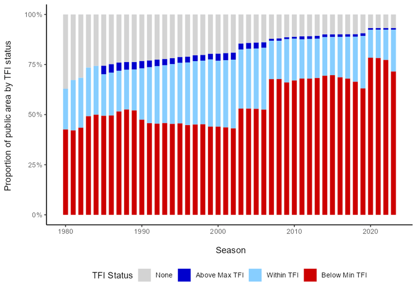
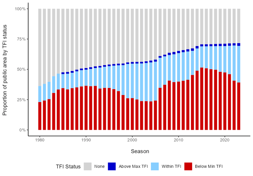
Figure 9 indicates the tolerable fire interval (TFI) status of vegetation on public land in the Barwon South West region since 1980. It indicates that in 2022–23:
- 23% of vegetation was below minimum TFI, 5% lower than in 2021–22
- 40% of vegetation was within TFI, 2% higher than in 2021–22
- the proportion of vegetation above maximum TFI remained stable at 10%.
These figures continue the positive trend of post-fire regeneration since 2015.
Figure 9: TFI status of vegetation on public land in the Barwon South West region since 1980. Data aligns with financial year
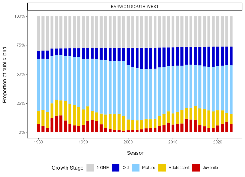
Figure 10: GSS status of vegetation on public land, Barwon South West region, 1980-2023. Data aligns with financial year

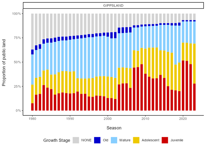
Figure 10 indicates the growth stage structure (GSS) status of vegetation on public land in the Barwon South West region since 1980. It indicates that in 2022–23:
- 7% of vegetation was in the juvenile growth stage, 2% lower than in 2021–22
- 9% of vegetation was in the adolescent growth stage, 2% higher than in 2021–22
- 16% of vegetation was in the old growth stage, which remained stable from 2021–22
- 42% of vegetation was in the mature growth stage, 1% point higher than in 2021–22.
Gippsland
Regional overview of the 2022-23 fire season
The Gippsland region has been impacted by increasingly frequent large-scale fires since 2000. These include notable fires such as in 2003, 2006/07, 2009 and the Black Summer fires which alone burnt 1 million hectares in 2019–20. As forest recovery from events such as these is slow, these areas will remain below the minimum Tolerable Fire Intervals (the minimum or maximum recommended time interval between successive fires in a vegetation community) for many years.
During this period these areas are in a state of increased vulnerability to species loss if impacted by further bushfires. In response, the Gippsland Region team undertakes adaptive strategies that aim to mitigate bushfire risk while protecting our forests and the species that live there.
The 2022–23 planned burning program focussed on 2 main objectives:
1. To strengthen fuel reduction areas immediately around communities that have been highly impacted by 2 decades of large bushfires
2. To reintroduce fire to the broader landscape to break up the reaccumulating fuel and reduce the number and extent of fires that develop in remote landscapes of Gippsland.
The return of more normal conditions to the east of the region after the higher rainfall conditions of the La Niña event in the previous year enabled the delivery of 42 burns covering approximately 36,000 ha across the Gippsland Region.
The program included many small to medium-sized burns to protect communities such as Waratah Bay, Latrobe Valley, Erica, Briagolong, Bruthen, Lakes Entrance, Nowa Nowa, Bairnsdale, Omeo, Benambra, Orbost, Marlo, Bendoc and Cann River. The program also treated 5 large landscape mosaic burns located across the remote northern parts of Macalister, Tambo and Snowy districts. Several burns were conducted to meet ecological objectives in the Latrobe and Macalister districts.
In addition to planned burning 247 areas totalling 3,800 hectares were treated by non-burn fuel treatments such as slashing and mulching. The fuel treatment program was delivered using an adaptive approach, considering the cumulative impact that severe fires have had on ecological values.
An example of this is an area in East Gippsland that has avoided bushfires and provides an important refuge for many species. This area contains Sheoak habitat for the EPBC-listed South Eastern Glossy Black Cockatoo.
It also carries significant bushfire risk for local communities. In August 2022, the Snowy District in partnership with the regional Monitoring, Evaluation and Reporting (MER) team undertook a planned burn at Newmerella – Corringle Road. This burn was considered a high priority for the protection of Orbost but was also important for the protection of Glossy Black Cockatoo.
Modified burn practices including breaking up the block using a small walk-behind mulcher successfully protected the Glossy Black Cockatoo habitat while reducing bushfire fuels. As part of the MER program, the site is being monitored for juvenile Sheoak survivorship and Sheaok cone seed release, following the low-intensity planned burning undertaken. Understanding the impacts on seed release is important, as the seed is the only food source for the Glossy Black-Cockatoo.
Fuel management delivery
For the Gippsland region, the careful application of fuel treatments resulted in positive trends in fuel-driven bushfire risk reduction and ecosystem resilience and reflect carefully considered bushfire management strategies, which aim to minimise both bushfire risk and the impacts of fuel management activities on ecosystem resilience.
During 2022–23, the Latrobe District treated 1,799 hectares with planned burning, and Macalister District treated 27,053 hectares, Snowy District treated 1,581 hectares and the Tambo District treated 5,991 hectares with planned burning.
FFMVic delivered 3 cross-tenure burns with the CFA in the Gippsland region. Fuel was reduced on an additional 40,221 hectares through non-burn fuel treatments. The total cost of the Gippsland fuel management program was $23.3 million.
During 2022–23, Gippsland region fuel reduction activities were prioritised around fuel reduction burns and slashing and mowing.
Table 26: Fuel management activities, Gippsland region, 2022–23.
| Fuel reduction | Total Hectares | Number of treatments |
|---|---|---|
| Area treated by planned burning | 36,424 | 57 |
| Ecological burns | 1,094 | 7 |
| Risk reduction burns | 35,328 | 36 |
| Window/heap burns | 1 | 14 |
| Area treated by non-burn fuel treatments | 4,022 | 268 |
| Mechanical mulching: 22.41 hectares (6 treatments) | 22 | 6 |
| Mechanical slashing or mowing: 3,806.98 hectares (254 treatments) | 3,807 | 254 |
| Other methods: 192.19 hectares ( 8 treatments) | 192 | 8 |
| Total area treated to reduce fuel-driven bushfire risk | 40,446 | 325 |
Of the fuel reduction burns, Table 27 indicates burns by fire management zone. LMZ burns, which includes ecological burns, was 66% of burns delivered in the Gippsland region. Macalister District had the highest hectare coverage of burns, but the lowest number of burns. The number of burns in Latrobe and Tambo Districts was 74% of all burns delivered with 32% in Latrobe and 42% in Tambo.
Table 27: Fuel reduction by fire management zone, Gippsland region, 2022–23.
| Fire management zone | ||||
|---|---|---|---|---|
| APZ | BMZ | LMZ | Total | |
| Gippsland Region | 960 hectares (18 burns) | 11,323 hectares (11 burns) | 24,141 hectares (28 burns) | 36,424 hectares (57 burns) |
| Latrobe District | 30 hectares (6 burns) | 30 hectares (1 burn) | 1,740 hectares (11 burns) | 1,799 hectares (18 burns) |
| Mecalister District | 9,468 hectares ( 3 burns) | 17,585 hectares (3 burns) | 27,053 hectares (6 burns) | |
| Snowy District | 123 hectares (7 burns) | 1,457 hectares (2 burns) | 1,581 hectares (9 burns) | |
| Tambo District | 806 hectares (5 burns) | 1,825 hectares (7 burns) | 3,360 hectares (12 burns) | 5,991 hectares (24 burns) |
Fuel-driven bushfire risk
Gippsland’s long-term regional planning target is to maintain fuel-driven bushfire risk at or below 71% of maximum levels. Districts also have long-term planning targets for the management of fuel-driven bushfire risk which assist FFMVic in meeting the statewide target and long-term regional planning targets.
Table 28 indicates the current level of fuel-driven bushfire risk in the region and associated districts and how it has changed over the past 3 years.
Fuel-driven bushfire risk in Gippsland region remains below the long-term regional planning target at 46%.
Table 28: Fuel-driven bushfire risk, Gippsland region and districts, 2022–23 and previously reported.
| Fuel-driven bushfire risk | 2020-21 | 2021-22 | 2022-23 |
|---|---|---|---|
| Gippsland Region (Target 71%) | 43% | 43% | 46% |
| Latrobe District (Target 80%) | 86% | 83% | 84% |
| Macalister District (Target 65%) | 51% | 56% | 57% |
| Snowy District (Target 65%) | 4% | 5% | 8% |
| Tambo District (Target 65%) | 25% | 28% | 33% |
Three of the region's four districts remain below the long-term planning target, however fuel-driven bushfire risk in Latrobe District (84%) is above the target level of 80%.
Three years of higher-than-average rainfall associated with a La Niña climatic pattern have limited the ability to deliver fuel reduction through planned burning. Despite the unfavourable climatic conditions Latrobe District has been able to marginally reduce the fuel-driven bushfire risk from a high of 86% in June 2021 to 84% in June 2023.
Unfavourable weather conditions limited the extent and effectiveness of planned burning in Latrobe District in 2022-23. The La Nina climate pattern brought above-average rainfall during winter and spring which prevented delivery of fuel reduction through the use of planned burning.
Dry conditions developed during summer and that combined with high fire danger weather prevented the commencement of the planned burning program until autumn. Weather conditions were mostly unfavourable for the remainder of the year with the exception of two windows of suitable conditions in April during which the majority of the fuel reduction program was delivered.
Despite the adverse conditions the burning program treated 1,799 ha and limited the increase in fuel-driven bushfire risk to 1% (i.e. from 83% in 2021-22 to 84% in 2022-23).
Fuel-driven bushfire risk was further reduced by mechanical treatments covering 1,000 ha in fuel breaks around smaller rural communities and strategically distributed throughout the broader landscape. The risk reduction benefits of these non-burn fuel treatment activities are not yet able to be reflected in the risk figures due to modelling limitations.
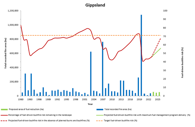
Figure 11 indicates the Gippsland region’s risk profile for 1980 to 2023 and projected changes in fuel-driven bushfire risk until 2026. It indicates fuel-driven bushfire risk in the Gippsland region:
- is projected to increase to 68% by 2026 in the absence of any fuel management activity or bushfires
- implementing the entire Joint Fuel Management Program would keep risk levels below the Gippsland region's long-term regional planning target of 71 %, and
- fell drastically in 2019–20, as major bushfires reduced fuel hazards, but these bushfires had significant impacts on property, industries, and the environment.
Figure 11: Bushfire risk profile, Gippsland region, 1980–2025. Data aligns with financial year
Ecosystem resilience
Figure 12 indicates the tolerable fire interval (TFI) status of vegetation on public land in the Gippsland region since 1980. It indicates that in 2022–23:
- 72% of vegetation was below minimum TFI, reflecting the significant area of public land burnt in the 2019-20 Black Summer bushfires
- 4% lower than the previous reporting period
- 21% of vegetation was within TFI, 5% higher than in 2020–21
- the proportion of vegetation with no recorded fire history remained stable at 7%.
It is expected that a high proportion of vegetation on public land in Gippsland will remain below minimum TFI for years to come, due to the extensive bushfires in 2019–20 and the time it takes for recovering vegetation communities to reach their TFI.
Figure 12: TFI status of vegetation on public land, Gippsland region, 1980–2023. Data aligns with financial year

Figure 13: GSS status of vegetation on public land, Gippsland region, 1980–2023. Data aligns with financial year

Figure 13 indicates the growth stage structure (GSS) status of vegetation on public land in the Gippsland region since 1980. It indicates that in 2022–23:
- 28% of vegetation was in the juvenile growth stage, 20% lower than in 2021–22
- 41% of vegetation was in the adolescent growth stage, 19% higher than in 2021–22
- 23% of vegetation was in the mature growth stage, and remained stable from 2021–22
- the proportion of vegetation in the old growth stage remained stable at 1%
- the proportion of vegetation with no recorded fire history remained stable at 7%.
The high proportion of vegetation in the juvenile growth stage reflects the landscape-scale bushfires of 2019–20. While there were modest improvements in the proportion of vegetation under TFI, it can be expected that vegetation in the juvenile and adolescent growth stages will form a dominant component of the growth stage structure on Gippsland’s public land for some years to come.
Grampians
Regional overview of the 2022-23 fire season
Widespread rainfall associated with a La Niña event across the state led to limited opportunity for any spring burn delivery, whilst on-ground conditions severely hampered burn preparation during spring. Leading into December, drying conditions across the Grampians Region enabled access for burn preparation, with resources diverted from Wimmera District to the Midlands to prioritise the region's highest risk-reducing burns.
From December to early March, rainfall was below average for the Region which resulted in the landscape that was too dry for a large-scale program of burning to commence early. Increased focus was subsequently given to mulching and other non-burn fuel treatment works in Asset Protection Zones across the Region.
Once stable autumnal conditions arrived, resources from the Wimmera were again deployed to the Midlands to ensure focus on the Grampian's highest priority risk-reducing burns.
High-priority burns were able to be delivered in the Midlands district around townships like Daylesford, Hepburn, Smythesdale, Linton, Ross Creek, Creswick and Ballarat. A return to wetter conditions in mid-April led to a restricted Autumn burning season in the Midlands, where many smaller operations burns resulted in several part-complete treatments requiring further treatment the next season.
Focus then shifted to the Wimmera District where a larger burn program was completed, including delivery of 25% of FFMVics Traditional Owner burns across Victoria.
Opportunities to deliver a more substantial program were missed due to the limited availability of aerial drip torch operators late in the season. Wind directions were also frequently unfavourable for internal break burning that takes place in the Little Desert. Once the autumn burn window in the Wimmera had closed, targeted winter ecological burns were delivered to protect the habitat of Heath Mouse, Southern Brown Bandicoot and Long-nosed Potoroo populations in Gariwerd National Park.
Fuel management delivery
The positive trends in risk reduction and ecosystem resilience reflect carefully considered bushfire management strategies. The strategies aim to minimise both fuel-driven bushfire risk and the impacts of fuel management activities on ecosystem resilience.
During 2022–23, the Grampians region delivered a mix of planned burning activities. Ecological burns were 45% of planned burns and fuel reduction burns treated 55% of the total hectares. FFMV supported 6 Traditional Owner burns. Slashing and mowing were the most non-burn fuel treatments at 9.6% of fuel reduction activities.
However, looking at the number of treatments NBFT had completed 185 activities compared to 43 planned burns. FFMVic delivered 2 cross-tenure burns with the CFA in the Grampians region.
The total cost of the Grampians fuel management program was $12 million.
Table 29 summarises the Grampians region’s fuel management activities in 2021–22.
Table 29: Fuel management activities, Grampians region, 2022–23.
| Fuel reduction | Total Hectares | Number of treatments |
|---|---|---|
| Area treated by planned burning | 21,945 | 43 |
| Ecological burns | 9,896 | 5 |
| Risk reduction burns | 12,048 | 30 |
| Window/heap burns | 0 | 8 |
| Area treated by non-burn fuel treatments | 2,131 | 185 |
| Mechanical mulching | 247 | 12 |
| Mechanical slashing or moving | 1,884 | 173 |
| Other methods | 0 | 0 |
| Total area treated to reduce fuel-driven bushfire risk | 24,076 | 228 |
By fire management zone, LMZ burns in the Wimmera were 86% of hectares treated 72% of LMZ planned burns across the region and 37% of all burns across the region. Compared to the Wimmera, Midlands prioritised burns in APZ with 88% of hectares burned in APZ across the region 71% of APZ burns across the region and only 12% of all planned burns across the region.
Table 30: Fuel reduction by fire management zone, Grampians, 2022–23.
| Fire management zone | ||||
|---|---|---|---|---|
| APZ | BMZ | LMZ | Total | |
| Grampians Region | 475 hectares (7 burns) | 2,303 hectares (14 burns) | 19,166 hectares (22 burns) | 21,945 hectares (43 burns) |
| Midlands District | 420 hectares (5 burns) | 831 hectares (7 burns) | 290 hectares (6 burns) | 1,541 hectares (18 burns) |
| Wimmera District | 55 hectares (2 burns) | 1,472 hectares (7 burns) | 18,876 hectares (16 burns) | 20,403 hectares (25 burns) |
Fuel-driven bushfire risk
The Grampians’ long-term regional planning target is to maintain fuel-driven bushfire risk at or below 70% of maximum levels. Districts also have long-term planning targets for the management of fuel-driven bushfire risk which assist FFMVic in meeting the statewide target and long-term regional planning targets.
Table 31 indicates the current level of fuel-driven bushfire risk in the region and its districts and how this has changed over the past 3 years.
Table 31: Fuel-driven bushfire risk, Grampians region and districts, 2022–23 and previously reported.
| Fuel-driven bushfire risk | 2020-21 | 2021-22 | 2022-23 |
|---|---|---|---|
| Grampians Region (Target 70%) | 75% | 76% | 77% |
| Midlands District (Target 70% | 75% | 78% | 79% |
| Wimmera District (Target 70%) | 43% | 48% | 41% |
Fuel-driven bushfire risk in the Grampians Region (77%) and Midlands District (79%) is above the long-term planning targets of 70%.
Key reasons for Grampians Region and Midlands District being above the long-term planning targets are outlined in Section 6.3.1.
In addition, the added complexity of the impact of storm debris within the Midlands District footprint has limited the capacity of FFMVic to effectively carry out planned burning in some target areas.
Mechanical debris removal works are underway which will allow this issue to be addressed as the removal program progresses.
The Midlands District has a ‘Model of Response’ - Regional Supplement for the 2023 Readiness and Response Plan, which provides District Duty Officers with guidance for enhanced response measures within the storm debris-impacted areas.
This includes but is not limited to guidance for additional plant and aircraft being activated in the first attack and readiness under elevated risk thresholds.
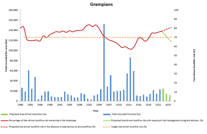
Figure 14 indicates the Grampians region’s risk profile for 1980 to 2023 and projected changes in fuel-driven risk until 2026. It indicates fuel-driven bushfire risk in the Grampians region:
- is projected to increase to 81% by 2026 in the absence of any fuel management activity or bushfires, and
- implementing the entire Joint Fuel Management Program would get risk levels below the Grampians Region's long-term regional planning target of 70%.
Figure 14: bushfire risk profile, Grampians region, 1980–2025. Data aligns with financial year
Ecosystem resilience
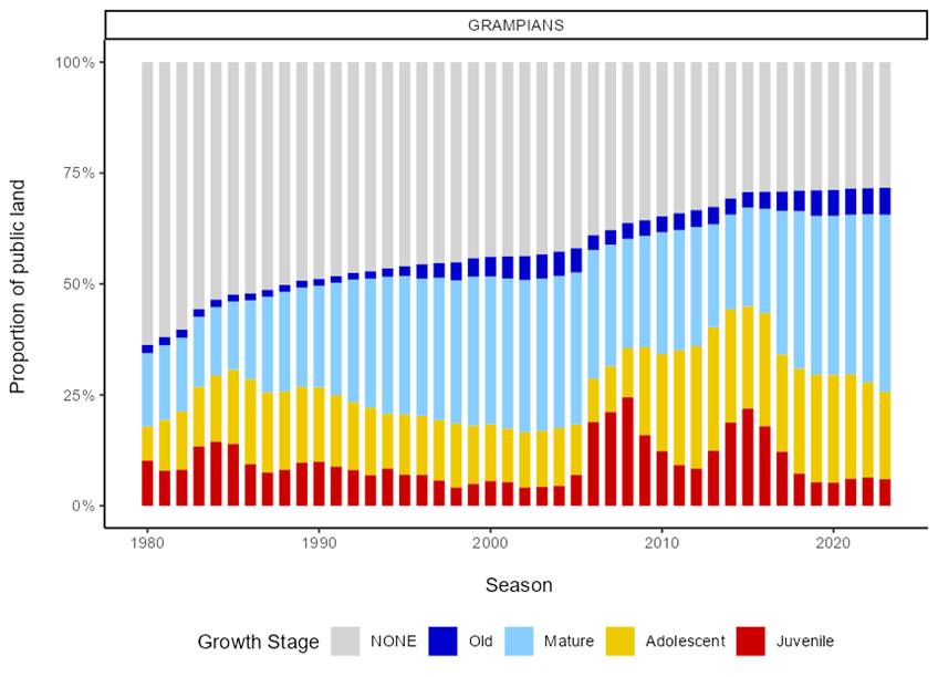
Figure 15 indicates the tolerable fire interval (TFI) status of vegetation on public land in the Grampians region since 1980. It indicates that on 30 June:
- 39% of vegetation was below minimum TFI, 3% higher than in 2021–22
- 30% of vegetation was within TFI, 3% higher than in 2020–21
- 2% of vegetation was above the maximum TFI
- the proportion of vegetation with no fire history remained stable at 25%.
In 2021–22, less than 1% of vegetation was impacted by bushfires or planned burning while under TFI, which was the same as the previous reporting period.
Much of the landscape remains below minimum TFI as areas regenerate after major bushfire events pre-2015 and slowly transition to older growth stages.
Figure 15 indicates this as an increase in the proportion of vegetation below minimum TFI, from 35% to about 50% between 2004–05 and 2014–15. This is a consequence of major bushfires in the Grampians National Park in 2006, 2013, and 2014, as well as in the region’s west in 2006 and 2012.
Figure 15: TFI status of vegetation on public land, Grampians region, 1980–2022. Data aligns with financial year
Figure 16: GSS status of vegetation on public land, Grampians region 1980–2022. Data aligns with financial year
Figure 16 indicates the growth stage structure (GSS) status of vegetation on public land in the Grampians region since 1980. It indicates that at 30 June 2023:
- the proportion of vegetation in the juvenile growth stage decreased to 6%
- 20% of vegetation was in the adolescent growth stages, 1% lower than in 2021–22
- 40% of vegetation was in the mature growth stages, 2% higher than in 2021–22
- the proportion of vegetation in the old growth stage remained stable at 6%
- the proportion of vegetation with no recorded fire history remained stable at 28%.
The changes in growth stages show the slow recovery of vegetation from the impact of major bushfires over the past 2 decades, with vegetation transitioning out of younger age classes into the mature class since 2015–16.
Hume
Regional overview of the 2022-23 fire season
The climate and weather conditions leading into summer 2022–23 were characterised by an increase in fuel moisture levels in all fuel types across the Hume region following on from the third consecutive La Niña event.
Significant summer rain fell across the state again in January 2023 with much of the Region receiving above-average rainfall and in some northern and eastern parts, well above-average falls.
Warm and dry conditions finally returned in February, particularly to the northern and western ends of the region where the below-average rainfall allowed for some drying and the curing of fine fuels, setting up some chance to get the Fuel Management Program underway.
The eastern end of the region and along the spine of the Great Divide was a complete contrast however receiving average rainfall meaning that the already heavily saturated soils and the lack of curing would limit any chances of getting any broad-scale planned burning underway in the Upper north-east.
Towards the end of March 2023, the Murrindindi and Goulburn districts were able to make a start with the bulk of this year’s planned burning program being delivered by those 2 western Hume districts.
A succession of rainfall events then progressively restricted the availability to conduct any landscape-scale burns and saw the program transition from the larger risk reduction burns to support some smaller Traditional Owner-led cultural burns and finally to the last of the windrow and heap burns by mid-June.
Hume region also provided resources to support delivery of the program across the State particularly as burns came on towards the end of March and into April in the west of the state.
Overall 49 personnel were sent as part of 3 Task Forces to Ballarat in the Grampians region. Another half Taskforce was deployed from the Ovens district to support delivery in the Goulburn district in early April.
Fuel management delivery
During 2022–23, the Hume region undertook a mix of fuel reduction activities. The region delivered risk reduction, ecological and windrow planned burns.
The region also delivered multiple types of non-burn fuel treatments, with 64% of treatments recorded as other methods (which may include works like weed spraying).
FFMVic delivered 1 cross-tenure burn with the CFA in the Hume region. The total cost of the Hume fuel management program was $19.9 million.
Table 32 summarises the region’s fuel management activities in 2022–23.
Table 32: Fuel management activities, Hume region, 2022–23.
| Fuel reduction | Total Hectares | Total Number of treatments |
|---|---|---|
| Area treated by planned burning | 6,488 | 23 |
| Ecological burns | 11 | 1 |
| Risk reduction burns | 6,451 | 15 |
| Window/heap burns | 26 | 7 |
| Area treated by non-burn fuel treatments | 4,150 | 196 |
| Mechanical mulching | 410 | 12 |
| Mechanical slashing or moving | 1,091 | 157 |
| Other methods | 2,648 | 27 |
| Total area treated to reduce fuel-driven bushfire risk | 10,638 | 219 |
Of fuel reduction by fire management zone in the Hume region (Table 33), most burns were delivered in BMZ. Of BMZ burns, Murrindindi and Goulburn districts delivered 59% of the total hectares burned in the region. 13% of regional burns were in LMZ.
Table 33: Fuel reduction by fire management zone, Hume region, 2022–23.
| Region | Fire management zone | |||
|---|---|---|---|---|
| APZ | BMZ | LMZ | Total | |
| Hume Region | 190 hectares (6 burns) | 5,447 hectares (13 burns) | 851 hectares (5 burns) | 6,488 hectares (23 burns) |
| Goulburn District | 91 hectares (1 burn) | 1,040 hectares (3 burns) | 22 hectares (1 burn) | 1,158 hectares (5 burns) |
| Murrindindi District | 94 hectares (1 burn) | 2,767 hectares (4 burns) | hectares (1 burn) | 2,861 hectares (6 burns) |
| Ovens District | 0 hectares (3 burns) | 821 hectares (2 burns) | 818 hectares (1 burn) | 1,650 hectares (6 burns) |
| Upper Murray District | 5 hectares (1 burn) | 819 hectares (4 burns) | 11 hectares (1 burn) | 835 hectares (6 burns) |
Fuel-driven bushfire risk
Hume’s long-term regional planning target is to maintain fuel-driven bushfire risk at or below 69% of maximum levels. Districts also have long-term planning targets for the management of fuel-driven bushfire risk which assist FFMVic in meeting the statewide target and long-term regional planning targets.
Table 34 indicates the current level of fuel-driven bushfire risk in the region and how it has changed over the past 3 years.
Table 34: Fuel-driven bushfire risk, Hume region and districts, 2022–23 and previously reported.
| Fuel-driven bushfire risk | 2020-21 | 2021-22 | 2022-23 |
|---|---|---|---|
| Hume Region (Target 69%) | 66% | 66% | 71% |
| Goulburn District (Target 75%) | 75% | 67% | 71% |
| Murrindindi District (Target 80%) | 80% | 76% | 80% |
| Ovens District (Target 55%) | 53% | 59% | 66% |
| Upper Murray District (Target 60%) | 40% | 45% | 42% |
Fuel-driven bushfire risk in the Hume Region (69%) and Ovens District (80%) is above the long-term planning targets of 69% and 55%, respectively. Fuel-driven bushfire risk in all other districts of the Hume Region is within long-term planning targets.
Key reasons for the Hume Region and Ovens District being above long-term planning target levels are outlined in Section 6.4.1.
The Hume region is focussing on getting JFMP Year 1 and selected JFMP Year 2 planned burns to Ready status to take advantage of all opportunities.
The highest priority will be given to those burns that provide the greatest reductions in risk. The region ensures that its operational and management team workforces are mobile and flexible to take advantage of localised conditions that allow burns to proceed.
Over recent years Hume has continued to undertake non-burn fuel treatments across the region. Non-burn fuel treatments can be undertaken at times and places when planned burning is unsuitable.
This program is well underway in preparation for the coming bushfire season.
Hume has also been well supported through funding for the construction of strategic fuel breaks for both landscape and asset protection. These breaks have been maintained in preparation for the upcoming bushfire season.
Response is also a critical component of mitigating bushfire risk. On the frontline, FFMVic in the Hume Region has 298 personnel including full-time firefighters and seasonal firefighters, fire lookout observers (across 16 towers) and fire support officers.
They are supported by 198 accredited incident management staff.
Hume’s firefighting equipment includes more than 81 ultralight tankers and 28 heavy tankers, as well as plant and trucks including bulldozers, tractors, graders, loaders, excavators and boats.
Additionally, a fleet of 10 aircraft will be located at airbases across the region. This fleet includes a mix of firebombing aircraft, air supervision and air intelligence gathering aircraft. Aircraft are strategically placed across the state according to risk.
To increase the effectiveness and efficiency of aircraft, a network of "dip tanks” has been constructed in remote areas to reduce turn-around times for aircraft.
The tanks have substantial water storage capacity that is accessible to helicopters fighting fires in mountainous terrain. The placement of the tanks was partly determined by historical issues where flight turnaround times were identified as a factor that, if reduced, would assist in minimising fire spread.
A number of mobile tanks, including “Heliskid”, are also in development to supplement the fixed tank network in the future.
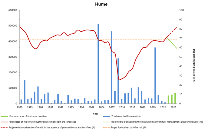
Figure 17 indicates the Hume region’s risk profile for 1980 to 2023 and projected changes in fuel-driven bushfire risk until 2026. It indicates fuel-driven bushfire risk in the Hume region:
- is projected to increase to 82% by 2026 in the absence of any fuel management activity or bushfires, and
- implementing the entire Joint Fuel Management Program would keep fuel-driven bushfire risk levels below the Hume region's long-term regional planning target of 69%.
Figure 17: Bushfire risk profile, Hume region, 1980-2025. Data aligns with financial year

Ecosystem resilience
Figure 18 indicates the tolerable fire interval (TFI) status of vegetation on public land in the Hume region since 1980. It indicates that in 2022–23, some changes have occurred as vegetation transitions between stages for vegetation:
- below minimum TFI, at 56% down 12% from 2021–22
- within TFI, at 31% and increase of 11% from 2021–22
- above maximum TFI remained at 1%.
In 2022–23, less than 1% of vegetation burnt by bushfire or planned burning was below minimum TFI. This was the result of careful planning to minimise the potential impacts of planned burns on vegetation below minimum TFI.
Figure 18: TFI status of vegetation on public land, Hume region, 1980-2023. Data aligns with financial year
Figure 19: GSS status of vegetation on public land, Hume region 1980-2023. Data aligns with financial year
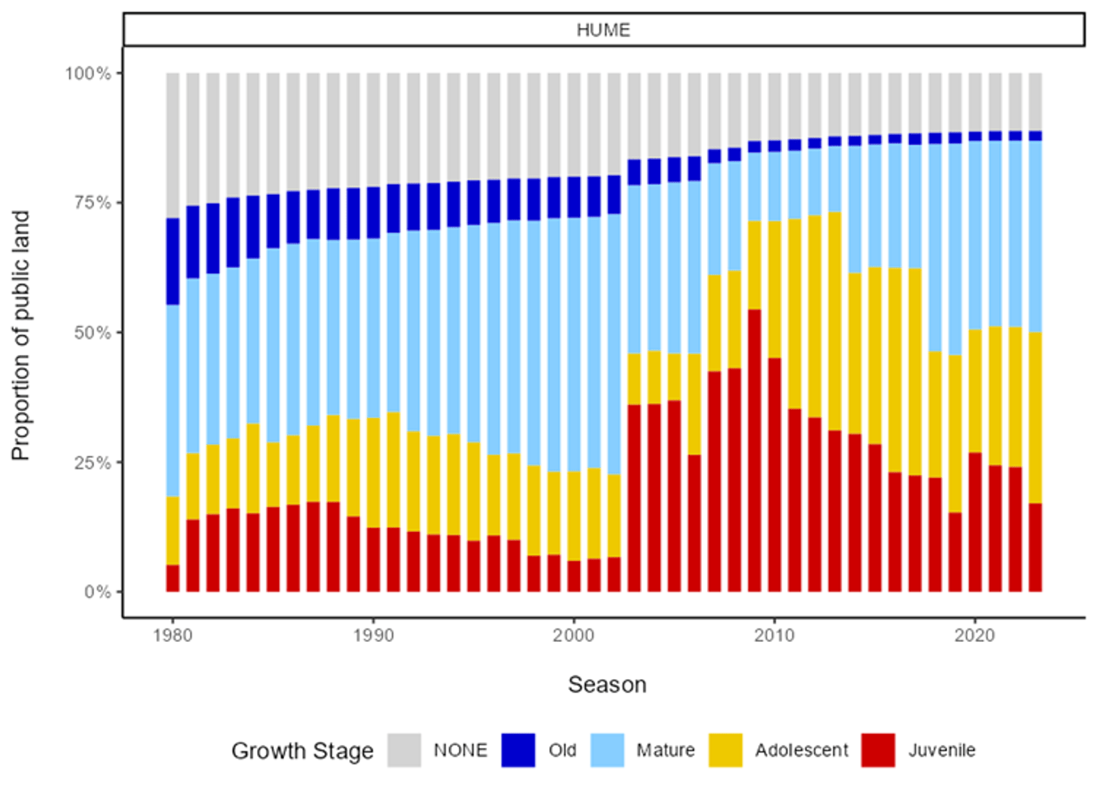
Figure 19 indicates the growth stage structure (GSS) status of vegetation on public land in the Hume region since 1980. It indicates that in 2022–23:
- 17% of vegetation was in the juvenile growth stage, a decrease of 7% from 2021–22
- 33% of vegetation was in the adolescent growth, and increase of 6% from 2021–22
- 37% of vegetation was in the mature growth stage, an increase of 1%from 2021–22
- 2% of vegetation was in the old growth stage
- 11% of vegetation had no fire history.
Loddon Mallee
Regional overview of the 2022-23 fire season
Fuel management in the Loddon Mallee region was impacted by a strong La Niña event bringing record-breaking rainfall in spring 2022.
This rainfall resulted in the region responding to a prolonged flood event along the Murray and other rivers within the region.
As a result, the public land road network was also significantly impacted and access to some areas was restricted. As the flooding subsided burn preparation was able to commence for the autumn season, no fuel management was conducted in spring due to this.
The Murray Goldfields District had a successful autumn season and focused on delivering the highest risk-reducing burns in and around Bendigo, Castlemaine, Macedon and the Pyrenees Ranges.
In addition to these burns which focused on protecting communities and infrastructure, there were 11 Traditional Owner burns conducted to promote a healthy Country and stimulate the growth of native plants that depend on fire, increasing biodiversity.
The Mallee district had a challenging season with less than favourable wind directions due to the La Niña but also managed a good outcome despite this.
The focus for the Mallee was continuing to develop and strengthen strategic corridors through the large parks including the Murray – Sunset National Park and Wyperfeld National Parks.
Both districts delivered large, over 2,000 hectares, of mechanical fuel treatments which included slashing, mulching, chaining, pruning, spraying and ploughing.
Loddon Mallee continued to deliver fuel management programs whilst also supporting other regions with specialist staff, such as aviation and IMT roles, and taskforces.
Fuel management delivery
During 2022–23, Loddon Mallee delivered 796 fuel treatments across 9,155 hectares. The total cost of the Loddon Mallee fuel management program was $12 million.
Table 35 summarises the region’s fuel management activities in 2021–22.
Table 35: Fuel management activities, Loddon Mallee region, 2022–23.
| Fuel reduction | Total hectares | Total number of treatments |
|---|---|---|
| Area treated by planned burning | 5,257 | 34 |
| Ecological burns | 0 | 0 |
| Risk reduction burns | 5,257 | 33 |
| Window/heap burns | 0.1 | 1 |
| Area treated by non-burn fuel treatments | 3,858 | 762 |
| Mechanical mulching | 1,267 | 152 |
| Mechanical slashing or mowing | 1,852 | 557 |
| Other methods | 739 | 53 |
| Total area treated to reduce fuel-driven bushfire risk | 9,115 | 796 |
Of planned burns undertaken in the Loddon Mallee region, 62% were prescribed BMZ burning, used to reduce the speed and intensity of bushfires and protect assets. This was highest in the Mallee District, totalling 75% of total BMZ hectares across the region.
In Murray Goldfields District, there were 12 BMZ and 13 LMZ planned burns. However, the treated hectares in LMZ were 59% less than the area treated in BMZ. BMZ burns in Murray Goldfields were 59% of planned burns for the district and 25% for the region.
Table 36: Fuel reduction by fire management zone, Loddon Mallee region, 2022–23.
| Fire management zone | ||||
|---|---|---|---|---|
| APZ | BMZ | LMZ | Total | |
| Loddon Mallee Region | 344 hectares (9 burns) | 4,390 hectares (21 burns) | 523 hectares (5 burns) | 5,258 hectares (34 burns) |
| Mallee District | 3,293 hectares (8 burns) | 252 hectares (2 burns) | 3,545 hectares (10 burns) | |
| Murray Goldfields District | 344 hectares (9 burns) | 1,096 hectares (12 burns) | 452 hectares (13 burns) | 1,893 hectares (35 burns) |
Loddon Mallee’s long-term regional planning target is to maintain fuel-driven bushfire risk at or below 75% of maximum levels. Districts also have long-term planning targets for the management of fuel-driven bushfire risk which assist FFMVic in meeting the statewide target and long-term regional planning targets.
Table 37 indicates the current level of fuel-driven bushfire risk in the region and how it has changed over the past 3 years.
Table 37: Fuel-driven bushfire risk, Loddon Mallee region and districts, 2022–23.
| Fuel-driven bushfire risk | 2020-21 | 2021-22 | 2022-23 |
|---|---|---|---|
| Loddon Mallee Region (Target 75%) | 71% | 70% | 73% |
| Mallee District (Target 90%) | 79% | 82% | 82% |
| Murray Goldfields District (Target 75%) | 70% | 69% | 73% |
The Loddon Mallee region successfully focused on delivering fuel treatments in priority risk-reduction areas, including Heathcote and Castlemaine. The Murray Goldfields District delivered 5 planned burns, making a significant contribution to reducing fuel-driven bushfire risk in the region.
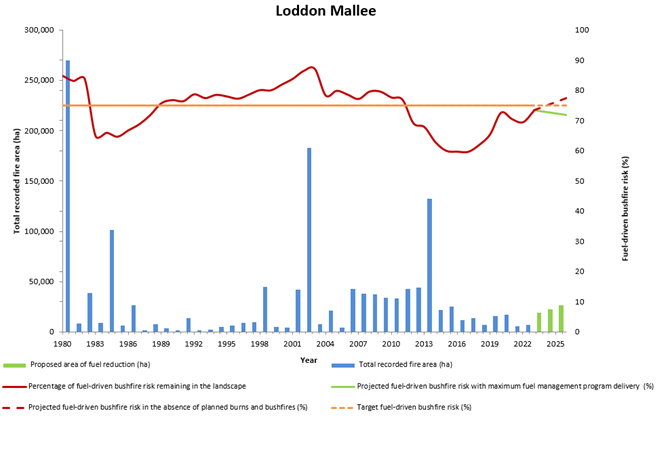
Figure 20 indicates the Loddon Mallee region’s risk profile for 1980 to 2023 and projected changes in fuel-driven bushfire risk until 2026. It indicates fuel-driven bushfire risk in the Loddon Mallee region:
- is projected to increase to 81% by 2026 in the absence of any fuel management activity or bushfires, and
- implementing the entire Joint Fuel Management Program would keep risk levels below the Loddon Mallee region's long-term regional planning target of 75%.
Figure 20: Bushfire risk profile, Loddon Mallee region, 1980-2025. Data aligns with financial year
Ecosystem resilience
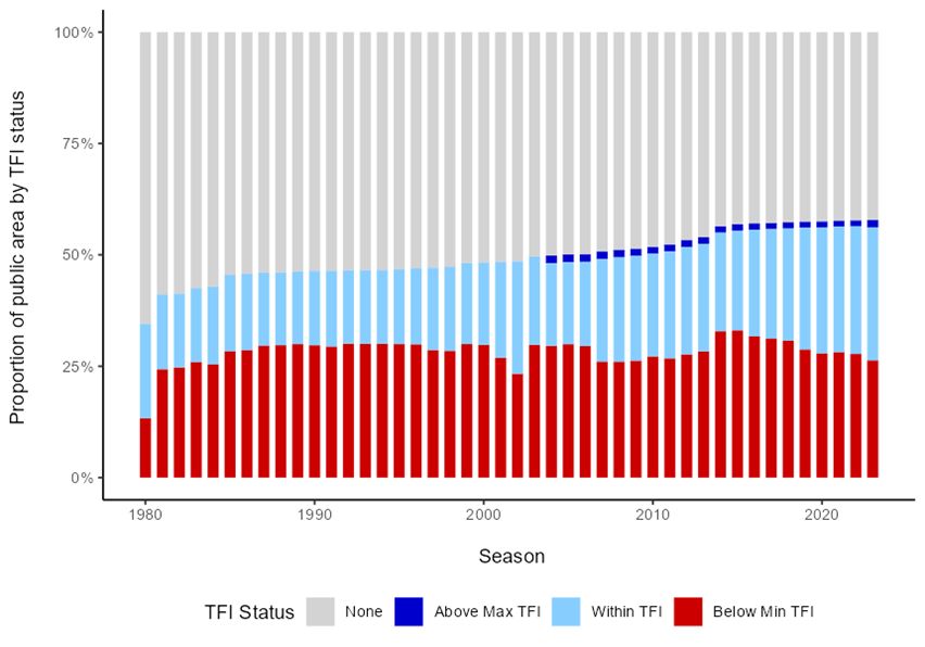
Figure 21 indicates the tolerable fire interval (TFI) status of vegetation on public land in the Loddon Mallee region since 1980. It indicates that in 2022–23:
- 26% of vegetation was below minimum TFI, 1% lower than in 2020–21
- the proportion of vegetation within TFI remained stable at 25%
- the proportion of vegetation above maximum TFI increased by 1 to 2%
- vegetation with no fire history has declined to 42%.
Figure 21: TFI status of vegetation on public land, Loddon Mallee region, 1980-2023. Data aligns with financial year

Figure 22: GSS status of vegetation on public land, Loddon Mallee region 1980-2023. Data aligns with financial year
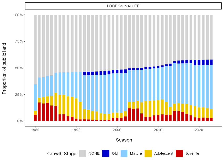
Figure 22 indicates the growth stage structure (GSS) status of vegetation on public land in the Loddon Mallee region since 1980. It indicates that in 2022–23:
- 3% of vegetation was in the juvenile growth stage, stable from 2021–22
- 8% of vegetation was in the adolescent growth stage, 1% point lower than in 2021–22
- 42% of vegetation in the mature growth stage, 1% point higher than in 2021–22
- the proportion of vegetation in the old growth stage remained stable at 5%
- the proportion of vegetation with no recorded fire history gradually declined over the past decade, to 42%.
Port Phillip
Regional overview of the 2022-23 fire season
Wet forests to the north and east of Melbourne drive much of the region’s fuel-driven bushfire risk, and these areas are typically too damp for large-scale planned burning.
This challenge was exacerbated by a third consecutive La Niña year resulting in challenging conditions for planned burning. During spring, fuels were consistently wet with flooding in large parts of the region.
From December to late March, there was a dry period with fuels drying out rapidly.
During this period the region delivered several ecological burns – predominantly west of Melbourne – to protect endangered native grasslands, and threatened species, as well as fuel reduction burns near Skye, Powelltown, and East Warburton for the protection of Melbourne’s water supply in the Upper Yarra catchment.
Rain in late March resulted in damp conditions which again prevented burning until late April – when districts were able to opportunistically reduce the fuel in drier sections of planned burns. This will enable more efficient completion of these treatments in the coming year.
Fuel management delivery
During 2022–23, the Port Phillip region treated more areas by non-burn fuel treatments (1,756 hectares), mainly slashing and mowing, compared to planned burning (1,531 hectares) as shown in Table 38.
Non-burn fuel treatments are an effective way of reducing fuels when conditions are not suitable for planned burning. FFMVic delivered 2 cross-tenure burns with the CFA in the Port Phillip region. The total cost of the Port Phillip fuel management program was $9.9 million.
Table 38 summarises the region’s fuel management activities in 2022–23.
Table 38: Fuel management activities, Port Phillip region, 2022–23.
| Fuel reduction | Total Hectares | Total Number of treatments |
|---|---|---|
| Area treated by planned burning | 1,531 | 28 |
| Ecological burns | 106 | 7 |
| Risk reduction burns | 1,384 | 10 |
| Window/ heap burns | 41 | 11 |
| Area treated by non-burn fuel treatments | 1,756 | 118 |
| Mechanical mulching | 521 | 10 |
| Mechanical slashing or mowing | 1,235 | 108 |
| Other methods | 0 | 0 |
| Total area treated to reduce fuel-driven bushfire risk | 3,287 | 146 |
Table 39 indicates fuel reduction by fire management zone. BMZ burning, which aims to reduce the speed and intensity of bushfires and protect assets, was the majority of planned burning in the region, with all but 8 hectares occurring in the Yarra District.
Table 39: Fuel reduction by fire management zone, Port Phillip region, 2022–23.
| Fire management zone | |||||
|---|---|---|---|---|---|
| APZ | BMZ | LMZ | Not Zoned | Total | |
| Port Phillip Region | 88 hectares (2 burns) | 1,320 hectares (9 burns) | 113 hectares (14 burns) | 11 hectares (3 burns) | 1,531 hectares (28 burns) |
| Metropolitan District | 8 hectares (2 burns) | 110 hectares (12 burns) | 117 hectares (14 burns) | ||
| Yarra District | 88 hectares (2 burns) | 1,312 hectares (7 burns) | 4 hectares (2 burns) | 11 hectares (3 burns) | 1,414 hectares (234 burns) |
Fuel-driven bushfire risk
Port Phillip’s long-term regional planning target is to maintain fuel-driven bushfire risk at or below 85% of maximum levels. Districts also have long-term planning targets for the management of fuel-driven bushfire risk which assist FFMVic in meeting the statewide target and long-term regional planning targets.
Table 31 indicates the current level of fuel-driven bushfire risk in the region and its districts and how this has changed over the past 3 years.
Table 40: Fuel-driven bushfire risk, Port Phillip region, 2022–23 and previously reported.
| Fuel-driven bushfire risk | 2020-21 | 2021-22 | 2022-23 |
|---|---|---|---|
| Port Phillip Region (Target 85%) | 84% | 85% | 89% |
| Metropolitan District (Target 85%) | 85% | 90% | 96% |
| Yarra District (Target 85%) | 84% | 84% | 88% |
Fuel-driven bushfire risk in the Port Phillip Region (89%), Metropolitan District (96%) and Yarra District (88%) is above the long-term planning target of 85%.
Key reasons for Port Phillip Region, Metropolitan and Yarra Districts being above the long-term planning targets are outlined in Section 6.5.1.
Port Phillip Region is aware of the long-term planning targets for the management of fuel-driven bushfire risk being exceeded and has considered it in the development of the Joint Fuel Management Plan (JFMP) 2023 Strategic Guidance Document which will inform the next operational planning cycle with the aim to return fuel-driven bushfire risk to target levels. Actions include:
- prioritising areas for fuel management treatments based on what will bring about the greatest reduction in regional risk
- reviewing existing fuel management nominations to take into account recent shifts in fuel hazard and the resultant risk after the La-Niña conditions
- nominating fuel management treatments that will complement fuel management treatments being delivered in neighbouring regions, and
- planning and preparing additional burns (those nominally planned for Year 2 of the JFMP) to take advantage of conditions when they are favourable.
In addition, Port Phillip is undertaking some immediate actions to manage the increased hazard posed by this season’s weather outlook, including:
- beginning the readiness roster earlier in the season
- undertaking continuing mechanical fuel treatment (e.g. slashing and mulching). It is important to note that the impact that these fuel treatments have on risk reduction is not accounted for in the risk evaluation. These are a significant proportion of the region’s fuel treatment program. The impact of mechanical fuel treatments is planned to be taken into account in upcoming enhanced strategic risk modelling.
- Considerable pre-season engagement with partner fire agencies at the district and brigade level to strengthen local relationships and ensure an integrated approach to the first attack this coming fire season.
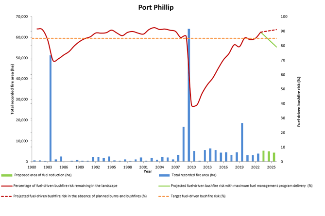
Figure 23 indicates the Port Phillip region’s risk profile for 1980 to 2023 and projected changes in fuel-driven bushfire risk until 2026. It indicates fuel-driven bushfire risk in the Port Phillip region:
- would increase to 91% by 2026 in the absence of any fuel management activity or bushfires, and
- implementing the entire Joint Fuel Management Program would keep risk levels below the Port Phillip region fuel-driven bushfire risk target of 85%.
Figure 23: Bushfire risk profile, Port Phillip region, 1980-2025. Data aligns with financial year

Ecosystem resilience
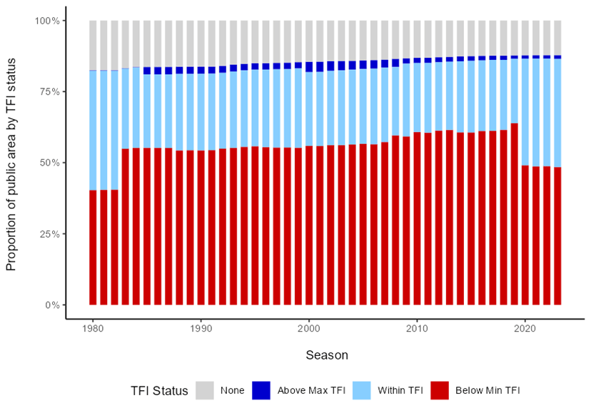
Figure 24 indicates the tolerable fire interval (TFI) status of vegetation on public land in the Port Phillip region since 1980. It indicates that in 2022–23:
- 48% of vegetation was below minimum TFI, 1% lower than in 2021–22
- 38% of vegetation was within TFI, stable from 2021–22
the proportion of vegetation above maximum TFI remained stable at 1%
Figure 24: TFI status of vegetation on public land, Port Phillip region, 1980-2023. Data aligns with financial year

Figure 25: GSS status of vegetation on public land, Port Phillip region 1980-2023. Data aligns with financial year
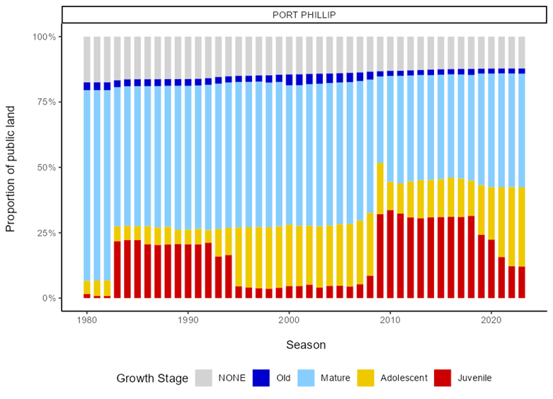
Figure 25 indicates the growth stage structure (GSS) status of vegetation on public land in the Port Phillip region since 1980. It indicates that in 2022–23:
- 12% of vegetation was in the juvenile growth stage, stable from 2021–22
- 30% of vegetation was in the adolescent growth stage, stable from 2021–22
- the proportion of vegetation in the mature growth stage remained stable at 43%
- the proportion of vegetation in the old growth stage remained stable at 2%
- the proportion of vegetation with no fire history remained stable at 12%.
Actions to address elevated fuel-driven bushfire risk in some regions
Fuel-driven bushfire risk levels in some regions and districts are currently exceeding long-term planning targets due to climate and weather conditions for the past three consecutive years making it challenging to find opportunities to deliver a broad-scale program of planned burning.
The third consecutive La Nina event for Australia in 2022-23 brought record rainfall in Spring 2022 which further increased the amount of moisture in an already wet landscape across much of Victoria.
Significant summer rain fell across the State again in January 2023 with almost the entire state receiving above-average rainfall, and in some instances over 400% of long-term averages. While February was dry across much of the state, improving conditions for delivery, March and April were relatively unstable for autumn with reduced forecast confidence, and again saw the return of above-average rainfall for much of the State with some areas recording over 200% of long-term averages.
Additionally, the added complexity of the impact of storm debris within the Midlands district footprint has limited the capacity of FFMVic to carry out planned burning in some target areas effectively. Fuel management in the Grampians Region was also limited by unfavourable wind conditions and reduced availability of aerial drip torch operators.
Actions being taken to reduce fuel-driven bushfire risk
FFMVic developed a three-year Joint Fuel Management Program (JFMP) which sets out the statewide program of fuel management works on public and private land.
Each region designs a JFMP with the intent of meeting the objectives of the regional Bushfire Management Strategies, including meeting long-term regional and district planning targets for managing fuel-driven bushfire risk. All FFMVic regions developed JFMPs in 2022-23 which were modelled to meet long-term regional risk planning targets by 2024-25.
While rainfall variability challenges the delivery of the planned burning program, FFMVic works to ensure that fuel-driven bushfire risk is being driven down to the greatest extent possible.
FFMVic’s approach to modelling the risk-reducing effectiveness of each burn ensures that they are always targeting burns that provide the greatest risk-reduction outcomes. Their flexible workforce management approach supports the deployment of resources across the State to take advantage of conditions that allow burns to proceed.
FFMVic will continue to prioritise the delivery of burns based on what will bring about the greatest reduction in risk. Burns in regions and districts with risk levels exceeding long-term planning targets will rank higher in risk modelling, ensuring that FFMVic prioritises those burns when conditions on the ground mean they are safe to deliver.
FFMVic is also focussing on getting burns on Years 1 and 2 of the JFMP to ‘Ready’ status (planned and prepared) so they can take advantage of all burning opportunities. This will help to ensure that long-term risk planning targets are met as planned for in the JFMP.
In the Midlands district, mechanical debris removal works are underway within areas of high priority which will change the structural arrangement of fuels whilst also reducing overall risks to the community in priority impacted areas.
The progression of these works will allow planned burning to be recommenced in some of these areas which will start to have risk reduction benefits.
Additionally, while the risk reduction benefits of non-burn fuel treatments are not yet captured by the modelling, FFMVic is continuing to expand its program of mowing and slashing to enable fuel management to proceed when conditions are not suitable for burning.
Additional actions are being taken ahead of the coming 2023-24 bushfire season
Planned burning is not the only way in which FFMVic manages bushfire risk. Other management actions undertaken by FFMVic support the planned burn program but are not reflected in current bushfire risk modelling.
Non-burn fuel treatments and strategic fuel breaks are effective at both improving fire agencies' ability to suppress bushfires and to successfully conduct planned burns.
Over recent years FFMVic has continued to invest in expanded non-burn fuel treatments and the construction and maintenance of strategic fuel breaks in preparation for the upcoming fire season.
Statewide, FFMVic will have close to 1,800 personnel on the frontline this bushfire season, including an additional 100 full-time Forest and Fire Operations Officers, which have bolstered year-round capability.
They are part of FFMVic’s 3,000 personnel who perform a fire or emergency role, which also include around 1,200 personnel who hold accreditations in incident management roles.
Readiness rosters commenced earlier this season to manage the increased hazard posed by this season’s weather outlook.
FFMVic firefighting equipment includes more than 500 ultralight tankers, around 100 heavy tankers, as well as more than 300 additional plant and trucks including bulldozers, tractors, graders, loaders, forklifts and excavators.
Ground operations are also supported by Victoria's aerial fleet of 51 aircraft contracted for the 2023-24 summer season. The fleet includes a mix of firebombing aircraft, air supervision and aerial information-gathering aircraft.
It is supplemented by up to 100 aircraft that can be called when needed. FFMVic’s response capabilities are also supported by a plant panel of around 400 contractors (including 19 harvest & haulage contractors) that can be called upon for bushfire suppression work using skilled personnel, bulldozers, graders, excavators, harvesters and other machinery.
Innovations including the Heliskid mobile water tank, and an improved fixed tank network will reduce helicopter turn-around times in remote areas of eastern Victoria, further increasing FFMVic’s ability to quickly suppress bushfires.
Readiness arrangements in place across the State take into consideration a range of factors including levels of fuel-driven bushfire risk, ensuring that firefighting personnel and equipment are prepositioned to optimise bushfire suppression effectiveness.
Considerable pre-season engagement with partner fire agencies at the district and brigade level has also been undertaken to strengthen local relationships and ensure an integrated approach to the first attack this coming fire season.
Additionally, the Midlands District has in place a ‘Model of Response’ - Regional Supplement for the 2023 Readiness & Response Plan, which provides District Duty Officers with guidance for enhanced response measures within the storm debris-impacted areas.
This includes but is not limited to guidance for additional plant and aircraft being activated in the first attack and readiness under elevated risk thresholds.
Steps community members can take to reduce their risk
All Victorians need to know how to plan for and respond to fire. Everyone in Victoria who lives near forest, bush, grassland, or the coast needs to prepare their property for bushfire.
There are some simple steps you can take to get ready now:
- familiarise yourself with the new Australian Fire Danger Ratings and check them every day during the fire season
- make your fire plan and talk with your family about what you will do. Just as every family or household is unique, every plan will be different, and
- if you live in a regional area at risk of bushfires or grassfires, be prepared to leave early on very high-risk days or if a fire starts. Leaving early is the safest option.
Always monitor your location conditions and follow official warnings and advice using the Vic Emergency app, the VicEmergency hotline (1800 226 226) and your local ABC emergency broadcaster.
Updated