Barwon South West
Fuel-driven bushfire risk
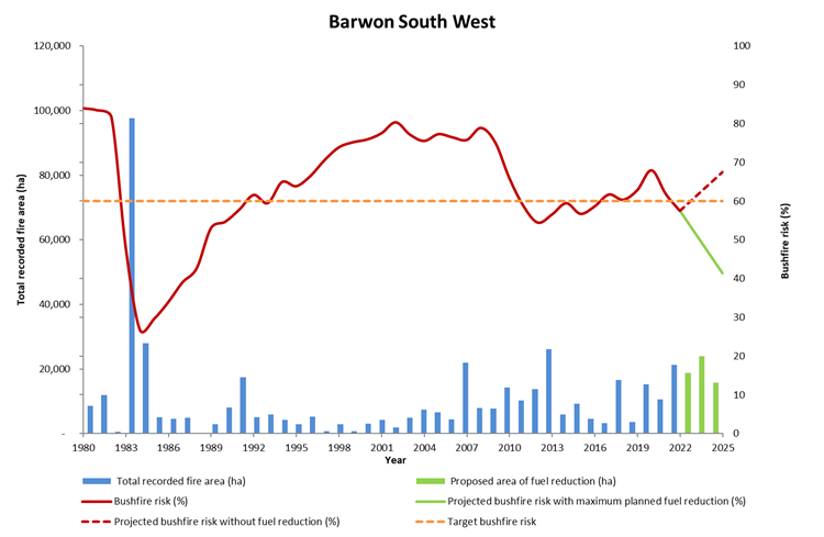
Barwon South West’s long-term regional planning target is to maintain fuel-driven bushfire risk at or below 60% maximum levels.
Fuel-driven bushfire risk in the Barwon South West region in 2021–22
- was 58% on 30 June 2022
- decreased by 4% from 62% at the end of 2020–21
- is projected to increase to 68% by 2025 in the absence of any fuel management activity or bushfires
- if implemented, the entire Joint Fuel Management Program would keep risk levels below the Barwon South West region's long-term regional planning target by 60%.
In 2021–22, fuel management was focused on providing the highest risk reduction possible within the constraints of seasonal weather conditions. Priority areas included the Surf Coast, Otway hinterland, and the Portland and Nelson areas.
Fuel treatments were predominantly planned burns, but mechanical treatments continue to be important to target difficult-to-burn areas along the Great Ocean Road.
Figure 10 shows the Barwon South West region’s risk profile from 1980 to 2022 and projected changes in fuel-driven bushfire risk until 2025.
Figure 10: Bushfire risk profile, Barwon South West region, 1980–2025. Data aligns with financial year.
Ecosystem resilience
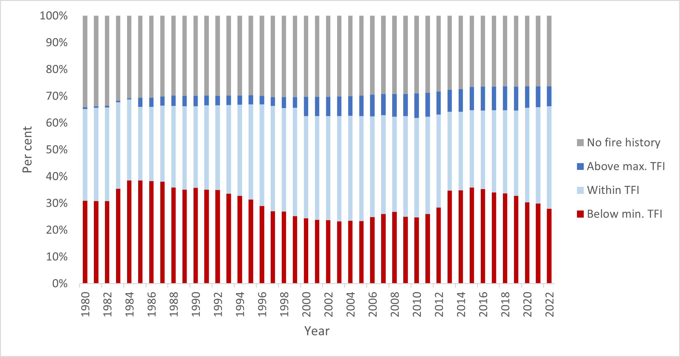
Figure 11 shows the tolerable fire interval (TFI) status of vegetation on public land in the Barwon South West region since 1980. It shows that in 2021–22:
- 28% of vegetation was below minimum TFI, 2% lower than in 2020–21
- 38% of vegetation was within TFI, 2% higher than in 2020–21
- the proportion of vegetation above maximum TFI remained stable at 8%.
These figures continue the positive trend of post-fire regeneration since 2015, supported by fire management strategies that aim to minimise the impacts of fuel management on species abundance, while improving ecological resilience with ecological burning.
Across the region, less than 1% of the vegetation burnt by bushfire or planned burning was below minimum TFI.
Figure 11: TFI status of vegetation on public land, Barwon South West region, 1980–2022. Data aligns with financial year.
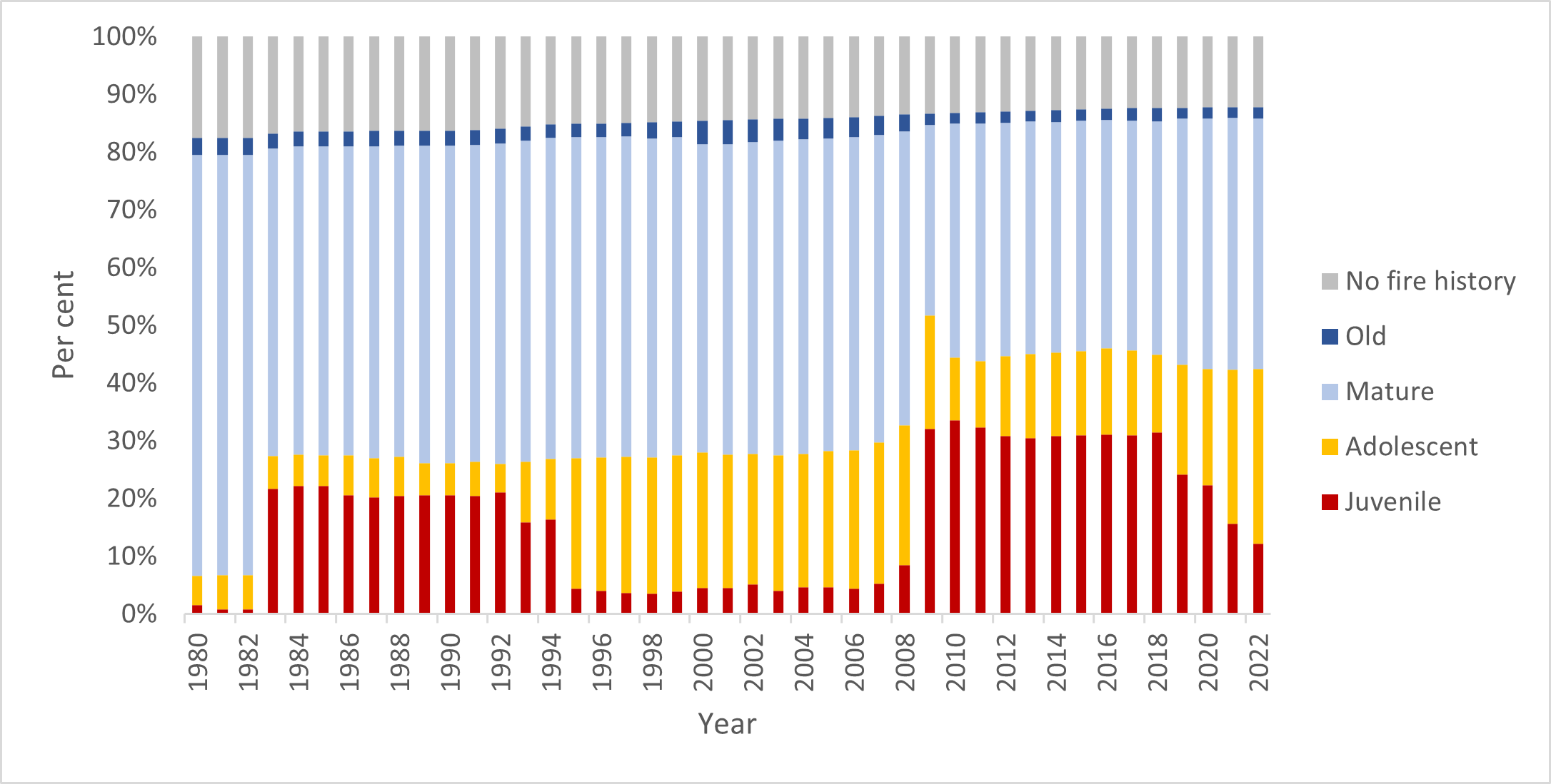
Figure 12 shows the growth stage structure (GSS) status of vegetation on public land in the Barwon South West region since 1980. It shows that in 2021–22:
- 9% of vegetation was in the juvenile growth stage, 1% higher than in 2020–21
- 7% of vegetation was in the adolescent growth stage, 4% lower than in 2020–21
- 16% of vegetation was in the old growth stage, 1% lower than in 2020–21
- 41% of vegetation was in the mature growth stage, 2% higher than in 2020–21.
Figure 12: GSS status of vegetation on public land, Barwon South West region, 1980–2022. Data aligns with financial year.
Fuel management delivery
The positive trends in bushfire risk reduction and ecosystem resilience reflect carefully considered fire management strategies – including ecological burning. The strategies aim to minimise both bushfire risk and the impacts of fuel management activities on ecosystem resilience.
During 2021–22, the Otway Fire District treated 13,504 hectares by planned burning district, while Far South West District treated 5,651 hectares.
Table 12 summarises the Barwon South West region’s fuel management activities in 2021–22.
Table 12: Fuel management activities, Barwon South West region, 2021–22
| Fuel reduction | Number of treatments | Hectares |
|---|---|---|
|
Area treated by planned burning Ecological burns: 550 hectares (6 burns) Fuel reduction burns: 18,510 hectares (49 burns) Other burns: 0.5 hectares (5 burns) |
60 | 19,060 |
|
Area treated by non-burn fuel treatments Mechanical mulching: 40 hectares (9 treatments) Mechanical slashing or mowing: 623 hectares (75 treatments) Other methods: 13 hectares (2 treatments) |
86 | 677 |
| Total area treated to reduce bushfire risk | 146 | 19,737 |
During the 2021–22 season, an easterly weather influence (from La Niña) delayed the drying of fuels along the coast, especially near Wye River and Lorne.
FFMVic adapted to the weather conditions and focused efforts where suitable fuels were available, resulting in a solid season with great risk reduction outcomes in the Otways region. At times the Otways District was supported by up to six Task Forces (approximately 132 personnel) from other parts of the state, in addition to significant support from the Burn Management Team. The program has a made a significant contribution to reducing risk to small communities such as Gellibrand and Forrest.
FFMVic also undertook several significant planned burns to reduce the spread of fires north of Aireys Inlet and Anglesea and north of the Otways. This will help protect coastal communities, and reduce the bushfire risk to the more sensitive wet forests and water catchments.
Far South West District was able to make use of burn windows successfully. Of note was the large program delivered in southern areas with priority burns in the Cobboboonee National Park.
The Barwon South West fuel management program took a 365-day approach, which involved planned burning and mechanical fuel treatments, and taking advantage of suitable winter burning conditions in heathlands. This resulted in great patchy burn outcomes. Without this approach, the significant level of risk reduction would not have been achieved.
Cultural burning
3 Traditional Owner led cultural burns were supported by Barwon South West in 2021–22.
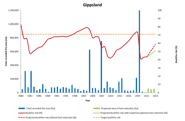
Gippsland
Fuel-driven bushfire risk
Gippsland’s long-term regional planning target is to maintain fuel-driven bushfire risk at or below 71% of maximum levels.
Fuel-driven bushfire risk in the Gippsland region in 2021–22
- was 43% on 30 June 2022
- remained at 43% since the end of the 2020–21
- is projected to increase to 59% by 2025 in the absence of any fuel management activity or bushfires
- if implemented, the entire joint Fuel Management Program would keep risk levels below the Gippsland region's long-term regional planning target at 71%
- fell drastically in 2019–20, as major bushfires reduced fuel hazards, but these bushfires had significant impacts on property, industries and the environment.
Planned burning in Gippsland in 2021–22 maintained fuel-driven bushfire risk at 43%. Gippsland had a reduced planned burning season due to wet La Niña conditions in autumn, with most of the region staying wet.
Despite this, the Latrobe District dried out enough over the spring and late autumn period to complete priority planned burns.
These included several key burns on the public–private land interface, and some complex burns close to the Mirboo North township and Tidal River campground.
Figure 13 shows the Gippsland region’s bushfire risk profile for 1980 to 2022 and projected changes in bushfire risk until 2025.
Figure 13: Bushfire risk profile, Gippsland region, 1980–2025. Data aligns with financial year.
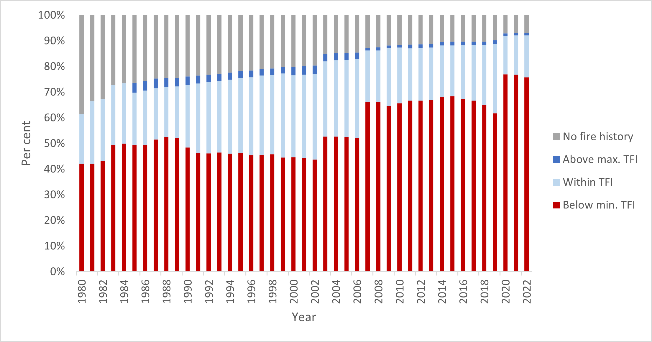
Ecosystem resilience
Figure 14 shows the tolerable fire interval (TFI) status of vegetation on public land in the Gippsland region since 1980. It shows that in 2021–22:
- 76% of vegetation was below minimum TFI, reflecting the significant area of public land burnt in the 2019-20 Black Summer bushfires
- 1% lower than the previous reporting period
- 16% of vegetation was within TFI, 1% higher than in 2020–21
- the proportion of vegetation with no recorded fire history remained stable at 7%.
It is expected that a high proportion of vegetation on public land in Gippsland will remain below minimum TFI for years to come, due to the extensive bushfires in 2019–20 and the time it takes for recovering vegetation communities to reach their TFI.
Figure 14: TFI status of vegetation on public land, Gippsland region, 1980–2022. Data aligns with financial year.
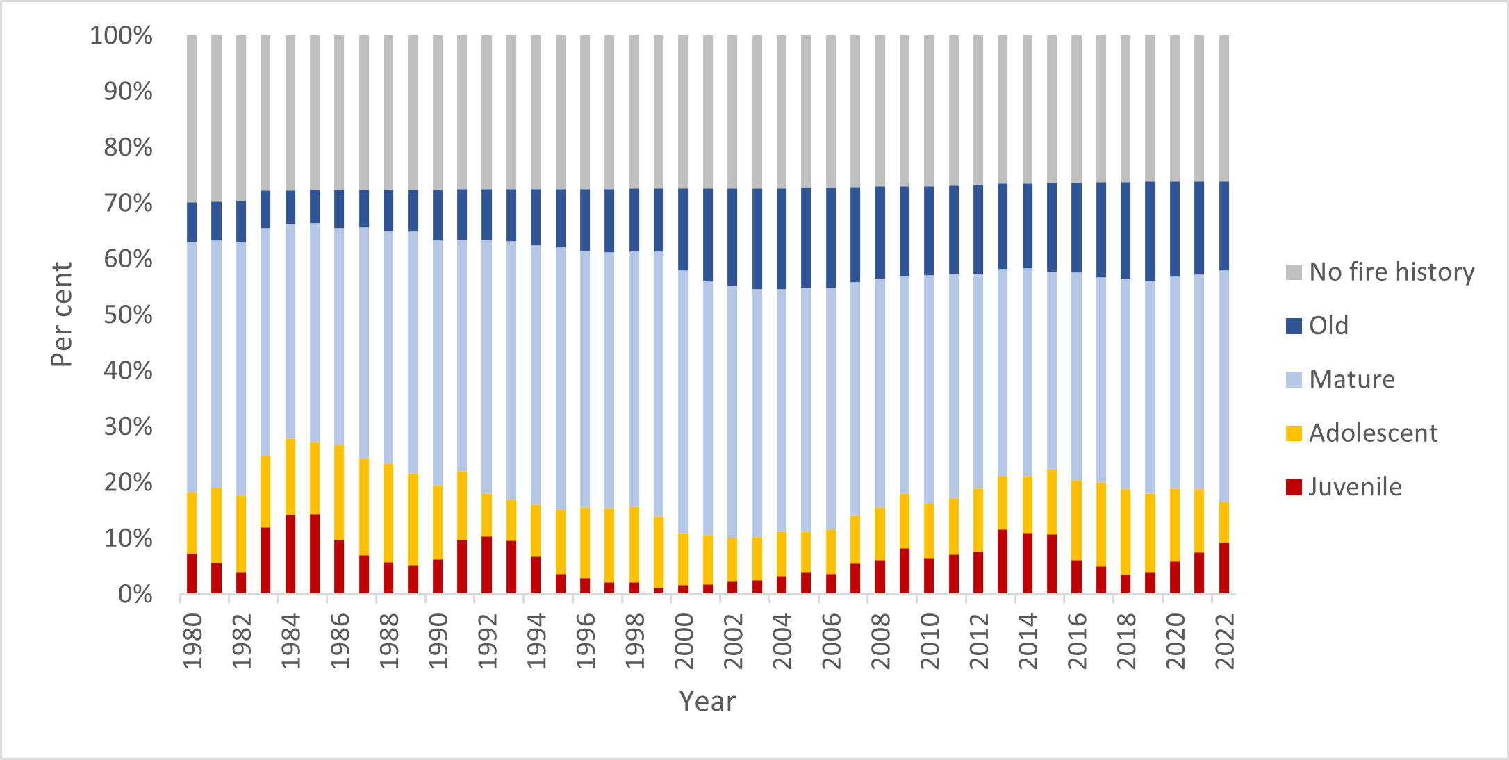
Figure 15 shows the growth stage structure (GSS) status of vegetation on public land in the Gippsland region since 1980. It shows that in 2021–22:
- 48% of vegetation was in the juvenile growth stage, 3% lower than in 2020–21
- 22% of vegetation was in the adolescent growth stage, 3% higher than in 2020–21
- 23% of vegetation was in the mature growth stage, 1% higher than in 2020–21
- the proportion of vegetation in the old growth stage remained stable at 1%
- the proportion of vegetation with no recorded fire history remained stable at 7%.
The high proportion of vegetation in the juvenile growth stage reflects the landscape-scale bushfires of 2019–20. While there were modest improvements in the proportion of vegetation under TFI, it can be expected that vegetation in the juvenile and adolescent growth stages will form a dominant component of the growth stage structure on Gippsland’s public land for some years to come.
Figure 15: GSS status of vegetation on public land, Gippsland region, 1980–2022. Data aligns with financial year.
Fuel management delivery
For Gippsland regions, the careful application of fuel treatments resulted in positive trends in bushfire risk reduction and ecosystem resilience and reflect carefully considered fire management strategies, which aim to minimise both bushfire risk and the impacts of fuel management activities on ecosystem resilience.
During 2021–22, the Gippsland region treated 12,124 hectares. The total cost of the Gippsland fuel management program was $22.3 million.
Table 13 summarises the Gippsland region’s fuel management activities in 2021–22.
Table 13: Fuel management activities, Gippsland region, 2021–22
| Fuel reduction | Number of treatments | Hectares |
|---|---|---|
|
Area treated by planned burning Ecological burns: 888 hectares (5 burns) Fuel reduction burns: 8,002 hectares (25 burns) Other burns: 73 hectares (15 burns) |
45 | 8,963 |
|
Area treated by non-burn fuel treatments Mechanical mulching: 26 hectares (5 treatments) Mechanical slashing or mowing: 2,985 hectares (310 treatments) Other methods: 150 hectares (7 treatments) |
322 | 3,161 |
| Total area treated to reduce bushfire risk | 367 | 12,124 |
FFMVic undertook 45 planned burns that treated 8,963 hectares in the Gippsland region as part of the 2021–22 Joint Fuel Management Program. This included five ecological burns and 25 fuel reduction burns, and supporting one Traditional Owner-led burn in partnership with Gunaikurnai Land and Waters Aboriginal Corporation. An additional 3,161 hectares were treated by non-burn fuel treatments.
Because a La Niña event and a positive southern annular node (a climate driver that can influence rainfall and temperature) resulted in wet conditions, delivery of planned burns was limited across Macalister, Tambo, Snowy and parts of Latrobe District throughout 2021–22.
Conditions favourable for planned burning returned in spring and late autumn, allowing Latrobe District to deliver 17 planned burns and treat 6,007 hectares.
With limited opportunities for burning in the east of the region, Gippsland deployed 16 task forces to other regions to contribute to the statewide planned burn program.
Grampians
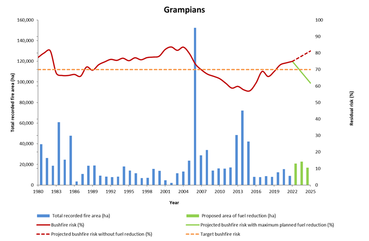
Fuel-driving bushfire risk
The Grampians’ long-term regional planning target is to maintain fuel-driven bushfire risk at or below 70% of maximum levels.
Fuel-driven bushfire risk in the Grampians region in 2021–22
- was 75% on 30 June 2022
- increased by 1% from 74% at the end of 2020–21
- is 5% higher than the long-term regional planning target of 70%
- is projected to increase 81% by 2025 in the absence of any fuel management activity bushfires
- if implemented, the entire Joint Fuel Management Program would get risk levels below the Grampians region's long-term regional planning target to 70%
Delivery of planned burns in the Grampians region in 2021–22 was impacted by the significant storm event that impacted the Wombat State Forest in June 2021.
This prevented the delivery of 18 planned burns as resources needed to be prioritised for emergency works to reopen the road network and undertake considerable additional preparation works for burns in the Midlands District prior to ignition.
However, the fuel management program for Midlands for 2021–22 also included additional mechanical mulching in high-priority areas such as Daylesford and its surrounds, which benefits risk reduction but has a small measurable contribution to the bushfire risk profile of the region.
FFMVic’s bushfire risk reduction program will need to focus on reducing fuel-driven bushfire risk in the Grampians region back to target levels, subject to other statewide priorities and suitable weather conditions.
Every year, FFMVic undertakes a detailed risk analysis to determine preparedness levels for bushfire suppression which determines the number and location of firefighters, aircraft and plant and equipment positioned in each district across the State.
In undertaking this analysis, FFMVic takes into consideration the fuel-driven bushfire risk levels, the season outlook, and local conditions. The level of fuel-driven bushfire risk in the Grampians region will inform this analysis.
Communities always have an important role to play in managing bushfire risk.
Communities in the Grampians region and other parts of the State can reduce their bushfire risk by preparing and practising their fire plans, abiding by relevant laws and regulations to prevent bushfires from starting, listening out for community warnings, and evacuating as advised.
Figure 16 shows the Grampians region’s risk profile from 1980 to 2022 and projected changes in fuel-driven risk until 2025. It shows fuel-driven bushfire risk in the Grampians region:
Figure 16: Fuel driven bushfire risk profile, Grampians region, 1980–2025. Data aligns with financial year
Ecosystem resilience
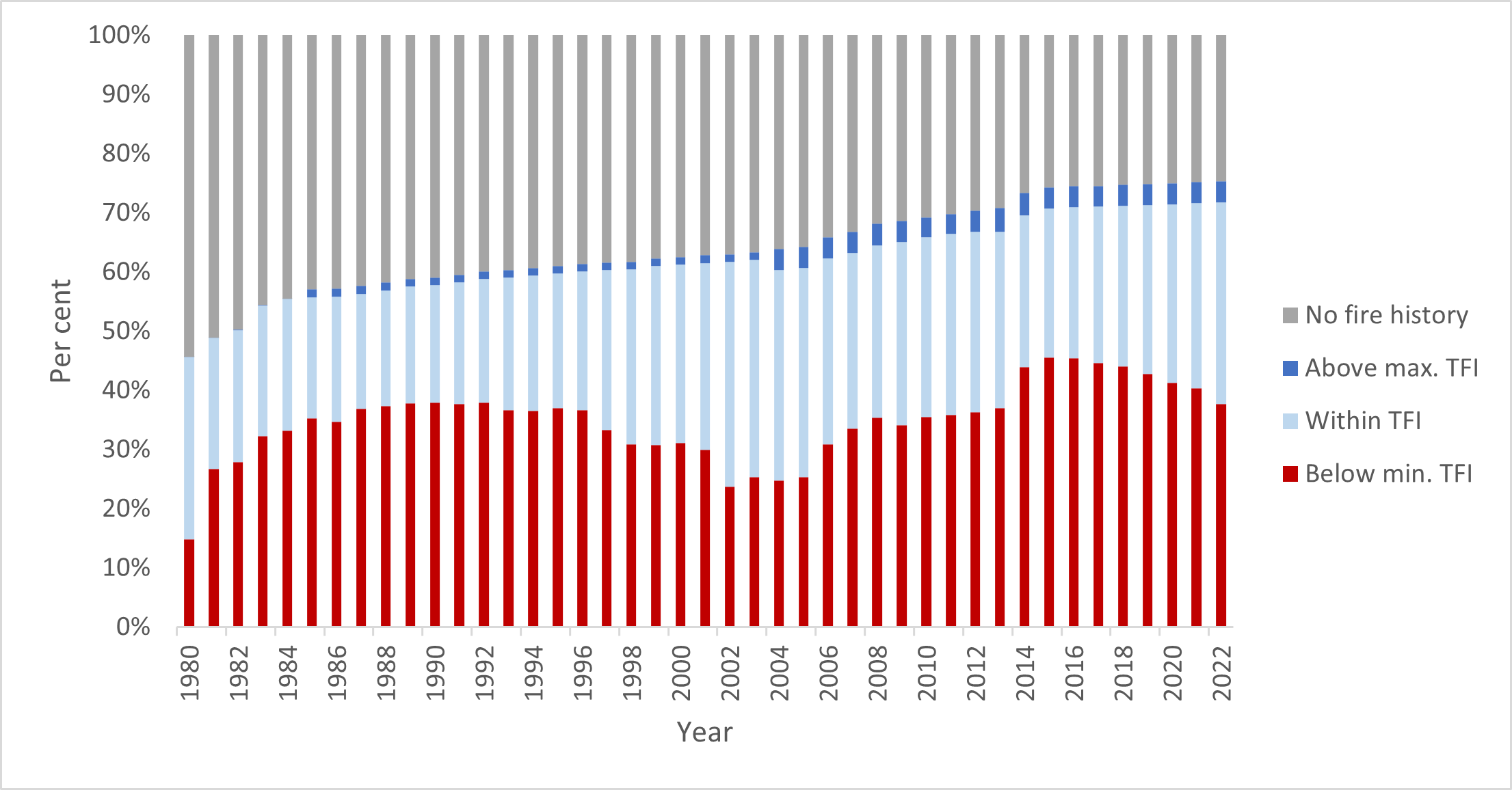
Figure 17 shows the tolerable fire interval (TFI) status of vegetation on public land in the Grampians region since 1980. It shows that at 30 June:
- 38% of vegetation was below minimum TFI, 3% higher than in 2020–21
- 34% of vegetation was within TFI, 3% higher than in 2020–21
- 4% of vegetation was above the maximum TFI
- the proportion of vegetation with no fire history remained stable at 25%.
In 2021–22, less than 1% of vegetation was impacted by bushfire or planned burning while under TFI, which was the same as the previous reporting period.
Much of the landscape remains below minimum TFI as areas regenerate after major bushfire events pre-2015 and slowly transition to older growth stages.
Figure 17 shows this as an increase in the proportion of vegetation below minimum TFI, from 35% to about 50% between 2004–05 and 2014–15. This is a consequence of major bushfires in the Grampians National Park in 2006, 2013, and 2014, as well as in the region’s west in 2006 and 2012.
Figure 17: TFI status of vegetation on public land, Grampians region, 1980–2022. Data aligns with financial year.
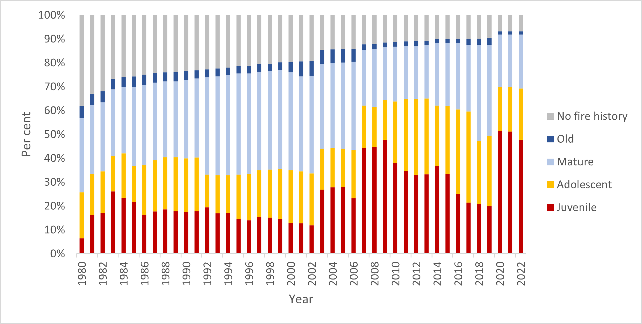
Figure 18 shows the growth stage structure (GSS) status of vegetation on public land in the Grampians region since 1980. It shows that at 30 June 2022:
- the proportion of vegetation in the juvenile growth stage remained stable at 7%
- 21% of vegetation was in the adolescent growth stages, 2% lower than in 2020–21
- 38% of vegetation was in the mature growth stages, 2% higher than in 2020–21
- the proportion of vegetation in the old growth stage remained stable at 6%
- the proportion of vegetation with no recorded fire history remained stable at 28%.
The changes in growth stages show the slow recovery of vegetation from the impact of major bushfires over the past two decades, with vegetation transitioning out of younger age classes into the mature class since 2015–16.
Figure 18: GSS status of vegetation on public land, Grampians region 1980–2022. Data aligns with financial year.

Fuel management delivery
The positive trends in risk reduction and ecosystem resilience reflect carefully considered bushfire management strategies. The strategies aim to minimise both fuel-driven bushfire risk and the impacts of fuel management activities on ecosystem resilience.
During 2021–22, the Grampians region treated 14,815 hectares. This included 6 cross-tenure burns delivered with the CFA. The total cost of the Grampians fuel management program was $13.0 million.
Table 14 summarises the Grampians region’s fuel management activities in 2021–22.
Table 14: Fuel management activities, Grampians region, 2021–22
| Fuel reduction | Number of treatments | Hectares |
|---|---|---|
|
Area treated by planned burning Ecological burns: 136 hectares (4 burns) Fuel reduction burns: 11,410 hectares (39 burns) Other burns: 0.2 hectares (2 burns) |
45 | 11,547 |
|
Area treated by non-burn fuel treatments Mechanical mulching: 96 hectares (14 treatments) Mechanical slashing or mowing: 3,096 hectares (292 treatments) Other methods: 76 hectares (12 treatments) |
318 | 3,268 |
| Total area treated to reduce bushfire risk | 363 | 14,815 |
The Midlands District had a truncated planned burning season because of wetter-than-usual conditions from La Niña and storm impacts during autumn.
Major storm damage in the Wombat Forest required significant recovery works, so the focus moved from planned burn preparations to road access and community safety, with staff safety in conducting these works a compounding issue.
Midlands focused on burning in high-risk areas, including Blackwood, Daylesford and Macedon. In addition, there was focus on cross-tenure burning with Country Fire Authority partners, with excellent results in the Wheatsheaf Fire Scape Project area and Dereel.
The Wimmera District continued to reintroduce planned burns into fire scars from a series of large-scale bushfires between 2006 and 2014. These burns aim to create a mosaic of different age classes in vegetation to promote ecosystem resilience while reducing the risk of future large-scale bushfires in the park.
These burns also protect communities around the Grampians (Gariwerd) National Park, including Halls Gap and Pomonal. The district manages risk to the communities of Edenhope and Nhill through regular fuel reduction burns.
Cultural burning
5 Traditional Owner-led cultural burns were supported by the Grampians region in 2021–22.
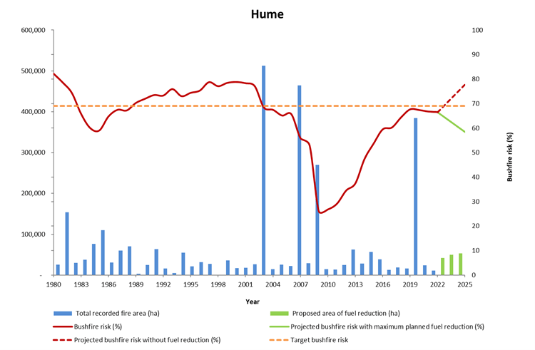
Hume
Fuel-driven bushfire risk
Hume’s long-term regional planning target is to maintain fuel-driven bushfire risk at or below 69% of maximum levels.
Fuel-driven bushfire risk in the Hume region in 2021–22
- was 67% at 30 June 2022
- remained at 67% since the end of 2020–21
- is projected to increase to 78% by 2025 in the absence of any fuel management activity or bushfires, and
- if implemented, the entire Joint Fuel Management Program would keep fuel-driven bushfire risk levels below the Hume region's long-term regional planning target of 69%.
Fuel reduction activity in 2021–22 was substantial across the region’s four districts and kept fuel-driven bushfire risk below the long-term regional planning target.
Figure 19 shows the Hume region’s risk profile for 1980 to 2022 and projected changes in fuel-driven bushfire risk until 2025. It shows fuel-driven bushfire risk in the Hume region.
Figure 19: Fuel driven bushfire risk profile, Hume region, 1980–2025. Data aligns with financial year.

Ecosystem resilience
Figure 20 shows the tolerable fire interval (TFI) status of vegetation on public land in the Hume region since 1980. It shows that in 2021–22, proportions remained stable for vegetation:
- below minimum TFI, at 69%
- within TFI, at 17%
- above maximum TFI, at 1%.
In 2021–22, less than 1% of vegetation burnt by bushfire or planned burning was below minimum TFI. This was the result of careful planning to minimise the potential impacts of planned burns on vegetation below minimum TFI.
Figure 20: TFI status of vegetation on public land, Hume region, 1980–2022. Data aligns with financial year.
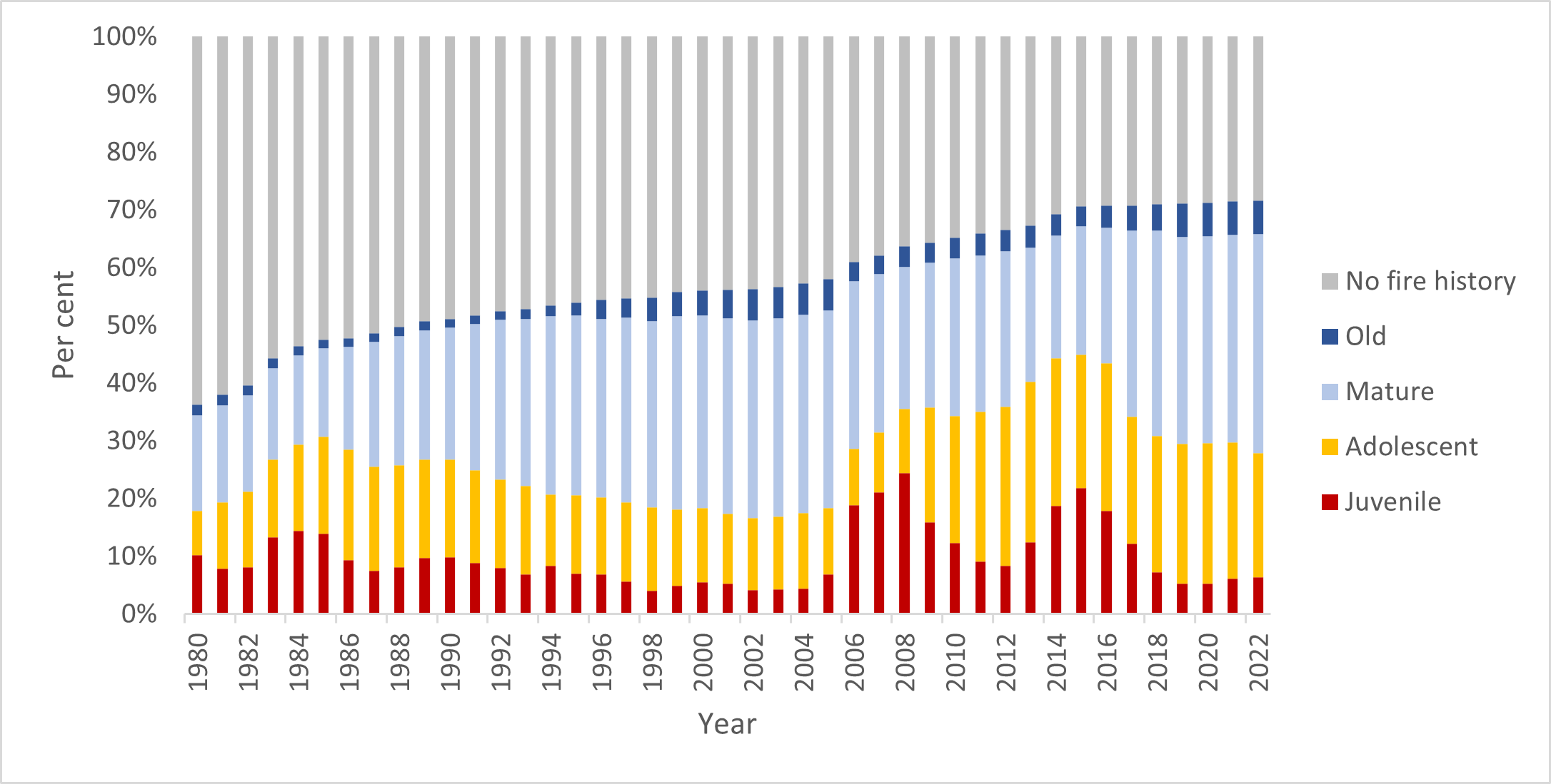
Figure 21 shows that in 2020–21 the proportion of vegetation remained stable for all growth stages at:
- 24% for the juvenile growth stage
- 27% for the adolescent growth stage
- 36% for the mature growth stage
- 2%for the old growth stage
- 11% for vegetation with no fire history.
Figure 21: GSS status of vegetation on public land, Hume region, 1980–2022. Data aligns with financial year.

Fuel management delivery
In 2021–22, the Hume region treated 16,576 hectares through planned burning, including ecological burns. This included 10 priority burns and one cross-tenure burn delivered with the CFA.
A further 3,598 hectares were treated by non-burn fuel treatment works, including 1,004 hectares with mechanical mowing or slashing, and a further 2,045 hectares by grazing. The total cost of Hume region’s fuel management program was $24.7 million.
Table 15 summarises the Hume region’s fuel management activities in 2021–22.
Table 15: Fuel management activities, Hume region, 2021–22
| Fuel reduction | Number of treatments | Hectares |
|---|---|---|
|
Area treated by planned burning Ecological burns: 9 hectares (1 burn) Fuel reduction burns: 16,566 hectares (31 burns) Other burns: 0.5 hectares (11 burns) |
43 | 16,576 |
|
Area treated by non-burn fuel treatments Mechanical mulching: 42 hectares (7 treatments) Mechanical slashing or mowing: 1,004 hectares (147 treatments) Other methods: 2,552 hectares (18 treatments) |
172 | 3,598 |
| Total area treated to reduce bushfire risk | 215 | 20,174 |
Weather conditions in the Hume region were characterised by a strong La Niña event bringing significant summer rainfall in early 2022, with much of the region receiving well above average rainfall. Warm and dry conditions returned in February, particularly to the western end of the region, with the lower rainfall enabling the fuel management program to begin.
By March 2022, the Murrindindi and Goulburn Districts in the west of the region were able to start on the fuel management program, with the bulk of the program delivered by these districts ahead of the autumn break in weather. Rainfall in autumn across the region left the two eastern districts – the Upper Murray and Ovens – too wet to deliver many planned burns, with only 17 days suitable for ignition of the larger landscape burns.
To capitalise on opportunities in other parts of the state, the Hume region provided resources to help deliver planned burning, with 8 taskforces deployed to Barwon South-West and Loddon Mallee regions.
Loddon Mallee
Fuel-driven bushfire risk
Loddon Mallee’s long-term regional planning target is to maintain fuel-driven bushfire risk at or below 75% of maximum levels.
Fuel-driven bushfire risk in the Loddon Mallee region in 2021–22
- was 68% on 30 June 2022
- decreased by 3% from 71% at the end of 2020–21
- is projected to increase to 77% in the absence of any fuel management activity or bushfires, and
- if implemented, the entire Joint Fuel Management Program would keep risk levels below the Loddon Mallee region's long-term regional planning target of 75%.
The Loddon Mallee region successfully focused on delivering fuel treatment in priority risk-reduction areas, including Heathcote and Castlemaine.
The Murray Goldfields District delivered 5 fuel reduction burns, making a significant contribution to reducing fuel-driven bushfire risk in the region.
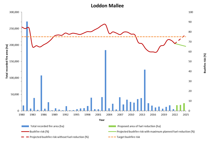
Figure 22 shows the Loddon Mallee region’s risk profile for 1980 to 2022 and projected changes in fuel-driven bushfire risk until 2025. It shows fuel-driven bushfire risk in the Loddon Mallee region.
Figure 22: Fuel driven bushfire risk profile, Loddon Mallee region, 1980–2025. Data aligns with financial year.
Ecosystem resilience
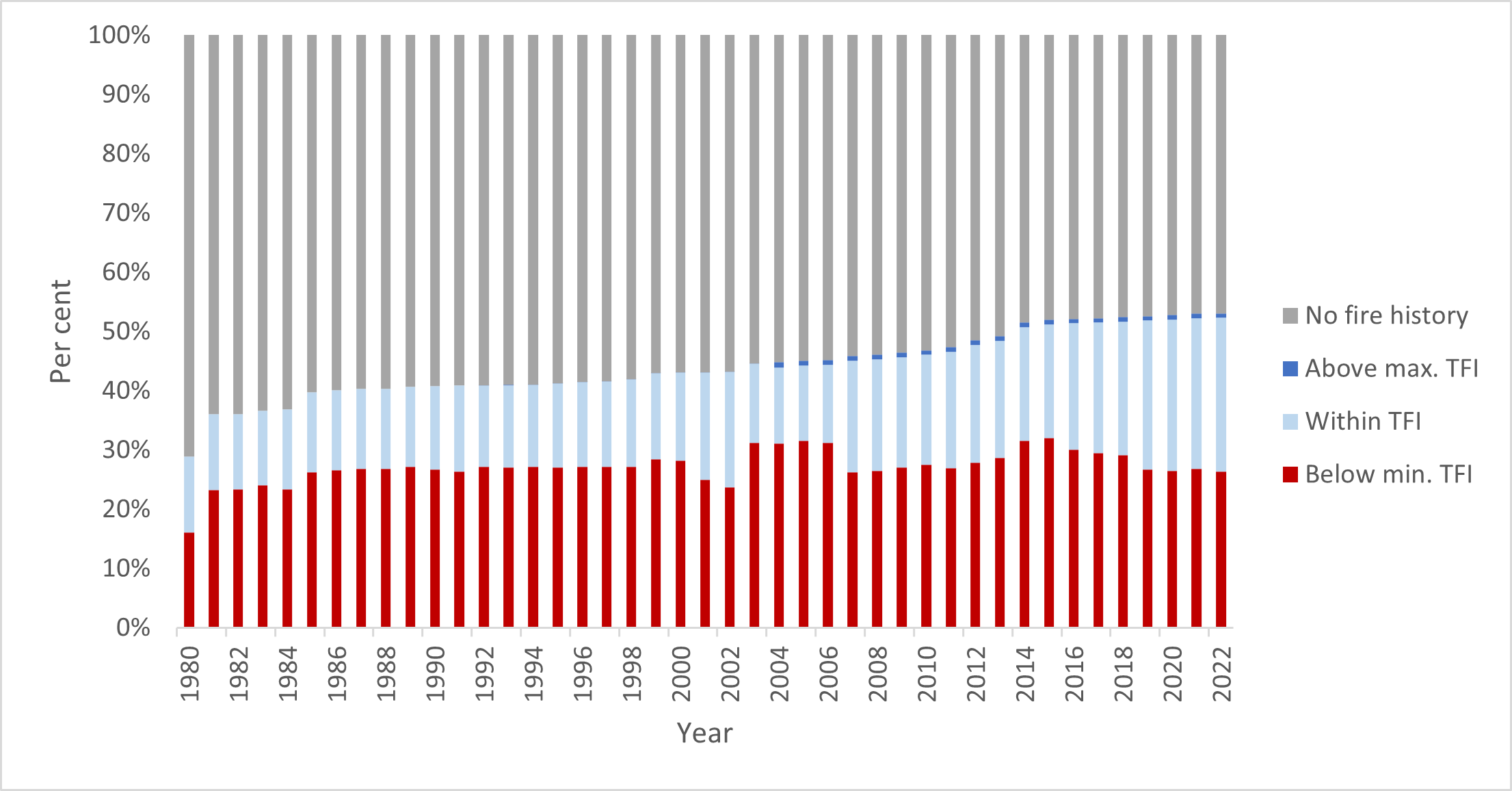
Figure 23 shows the tolerable fire interval (TFI) status of vegetation on public land in the Loddon Mallee region since 1980. It shows that in 2021–22:
- 26% of vegetation was below minimum TFI, 1% lower than in 2020–21
- the proportion of vegetation within TFI remained stable at 25%
- the proportion of vegetation above maximum TFI remained stable at 1%
- vegetation with no fire history has declined over the past decade, at 47%.
In 2021–22, less than 1% of vegetation burnt by bushfires or planned burning was below minimum TFI. This was the result of careful planning to minimise the potential impacts of planned burns on vegetation below minimum TFI.
Figure 23: TFI status of vegetation on public land, Loddon Mallee region, 1980–2022. Data aligns with financial year.

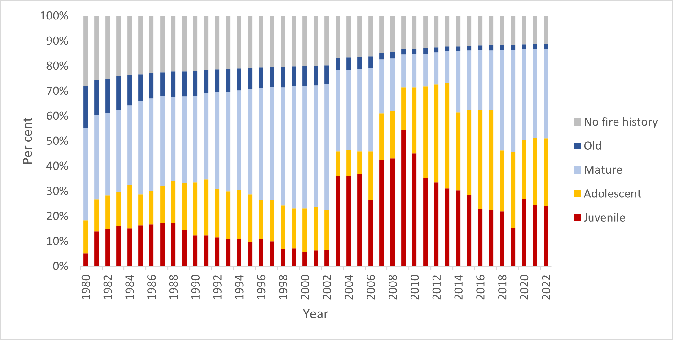
Figure 24 shows the growth stage structure (GSS) status of vegetation on public land in the Loddon Mallee region since 1980. It shows that in 2021–22:
- 3% of vegetation was in the juvenile growth stage, 1% lower than in 2020–21
- 9% of vegetation was in the adolescent growth stage, 1% lower than in 2020–21
- 41% of vegetation in the mature growth stage, 1% higher than in 2020–21
- the proportion of vegetation in the old growth stage remained stable at 5%
- the proportion of vegetation with no recorded fire history gradually declined over the past decade, at 42%.
Figure 24: GSS status of vegetation on public land, Loddon Mallee region, 1980–2022. Data aligns with financial year.
Fuel management delivery
In 2021–22, the Loddon Mallee region delivered 26 planned burns over 2,371 hectares, including one ecological burn.
A further 3,038 hectares were treated through non-burn fuel treatments. The total cost of Loddon Mallee region’s fuel management program was $11.6 million.
Table 16 summarises the region’s fuel management activities in 2021–22.
Table 16: Fuel management activities, Loddon Mallee region, 2020–21
| Fuel reduction | Number of treatments | Hectares |
|---|---|---|
|
Area treated by planned burning Ecological burns: 356 hectares (1 burn) Fuel reduction burns: 2,015 hectares (23 burns) Other burns: 0.5 hectares (2 burns) |
26 | 2,371 |
|
Area treated by non-burn fuel treatments Mechanical mulching: 451 hectares (28 treatments) Mechanical slashing or mowing: 2,259 hectares (694 treatments) Other methods: 328 hectares (37 treatments) |
759 | 3,038 |
| Total area treated to reduce bushfire risk | 785 | 5,409 |
The Loddon Mallee region continued to work on the network of fuel-reduced corridors in the Mallee parks. These corridors reduce the probability of large, landscape-scale bushfires impacting communities and the environment.
In the northern Mallee this work focused on the Big Desert State Forest and Wyperfeld National Park corridor network. Treated edge breaks will minimise bushfire risk to communities – including Yaapeet and Rainbow – by reducing the likelihood of bushfires exiting public land.
Loddon Mallee also built on fuel treatment work in priority areas for bushfire risk reduction for the townships of Bendigo, Castlemaine, Elphinstone, Glenluce, Heathcote, Macedon, Maryborough, St Arnaud and Taradale.
Small planned burns reduced bushfire risk close to high-density residential areas in southern and western Bendigo (including Maiden Gully–Fowlers Road, Kangaroo Flat–Tipperary Lane and Big Hill–Channel Track).
Considerable planning and engagement helped ensure that smoke did not impact vignerons and other businesses in the Heathcote and Castlemaine areas.
Cultural burning
5 Traditional Owner led cultural burns were supported by Loddon Mallee region in 2021–22.
Port Phillip
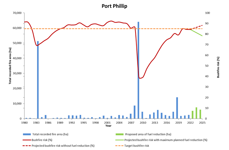
Fuel-driving bushfire risk
Port Phillip’s long-term regional planning target is to maintain fuel-driven bushfire risk at or below 85% of maximum levels.
Fuel-driven bushfire risk in the Port Phillip region in 2021–22
- was 84% on 30 June 2022
- remained at 84% since the end of 2020–21
- would increase to 88% by 2025 in the absence of any fuel management activity or bushfires, and
- implementing the entire Joint Fuel Management Program would keep risk levels below the Port Phillip region fuel-driven bushfire risk target of 85%.
Modelling has shown that wet forests to the north and east of Melbourne drive much of the region’s fuel-driven bushfire risk, and these areas are typically too damp for large-scale planned burning.
While the regional fuel-driven bushfire risk level did not reduce, the delivery of priority risk reduction burns ensured that the fuel-driven bushfire risk stabilised and did not increase, as it was forecast to do if no planned burning was achieved.
18 priority risk reduction burns were delivered in Port Phillip Region, focussed on the interface north-east of Melbourne, the Dandenong and Yarra Ranges, and the forested areas in and around Melbourne’s water catchments.
Other key activities include the continued construction and maintenance of strategic fuel break networks through Melbourne’s water catchments, and mechanical fuel treatment in forest areas east of Melbourne.
Figure 25 shows the Port Phillip region’s risk profile for 1980 to 2022 and projected changes in fuel-driven bushfire risk until 2025. It shows fuel-driven bushfire risk in the Port Phillip region.
Figure 25: Fuel-driven bushfire risk profile, Port Phillip region, 1980–2025. Data aligns with financial year.
Ecosystem resilience
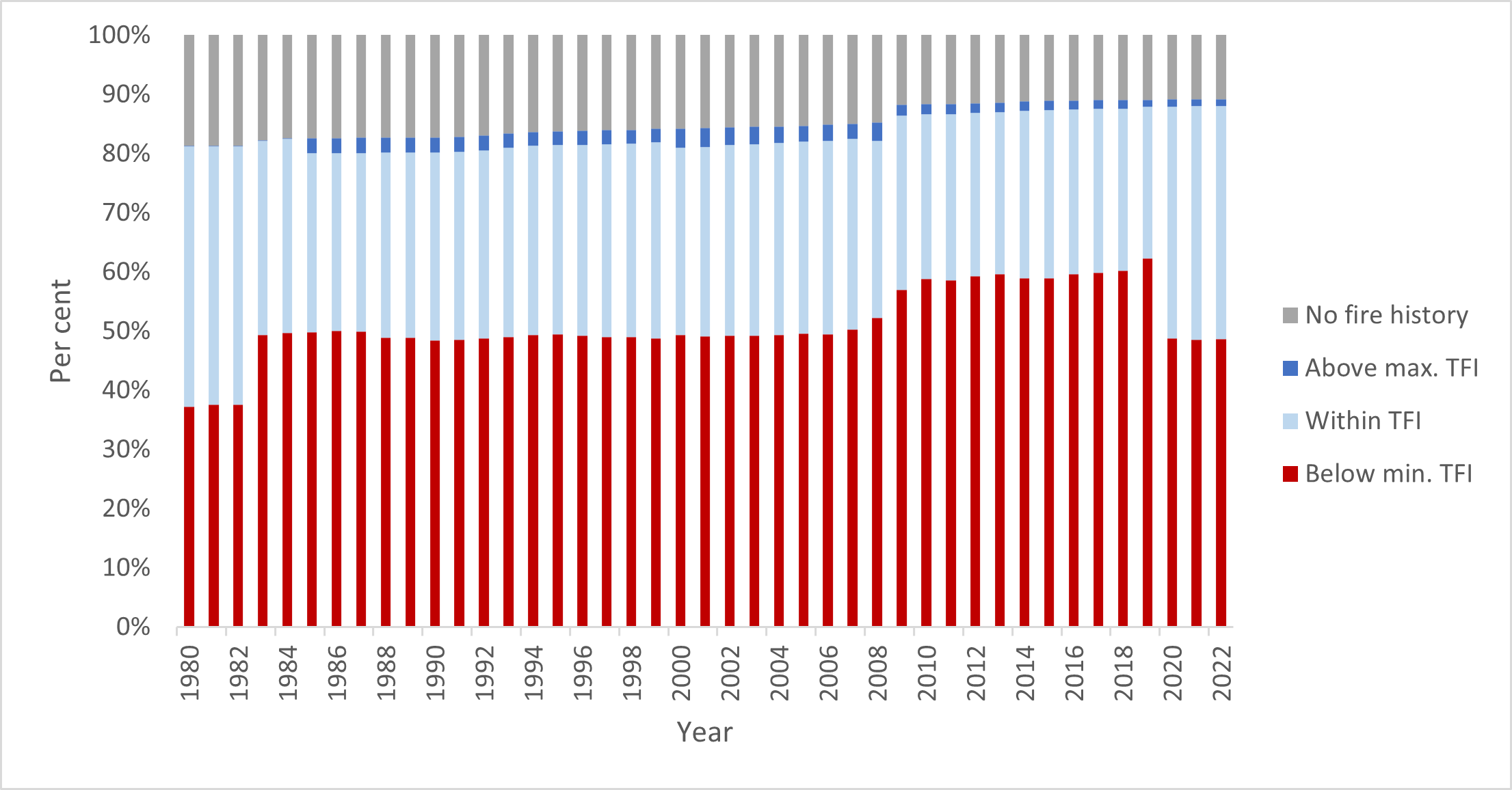
Figure 26 shows the tolerable fire interval (TFI) status of vegetation on public land in the Port Phillip region since 1980. It shows that in 2021–22:
- 49% of vegetation was below minimum TFI, 1% higher than in 2020–21
- 39% of vegetation was within TFI, 1% lower than in 2020–21
- the proportion of vegetation above maximum TFI remained stable at 1%.
In 2021–22, less than 1% of vegetation burnt by bushfire or planned burning was below minimum TFI, the result of careful planning to minimise the potential impacts of planned burns on vegetation below minimum TFI.
Figure 26: TFI status of vegetation on public land, Port Phillip region, 1980–2022. Data aligns with financial year.

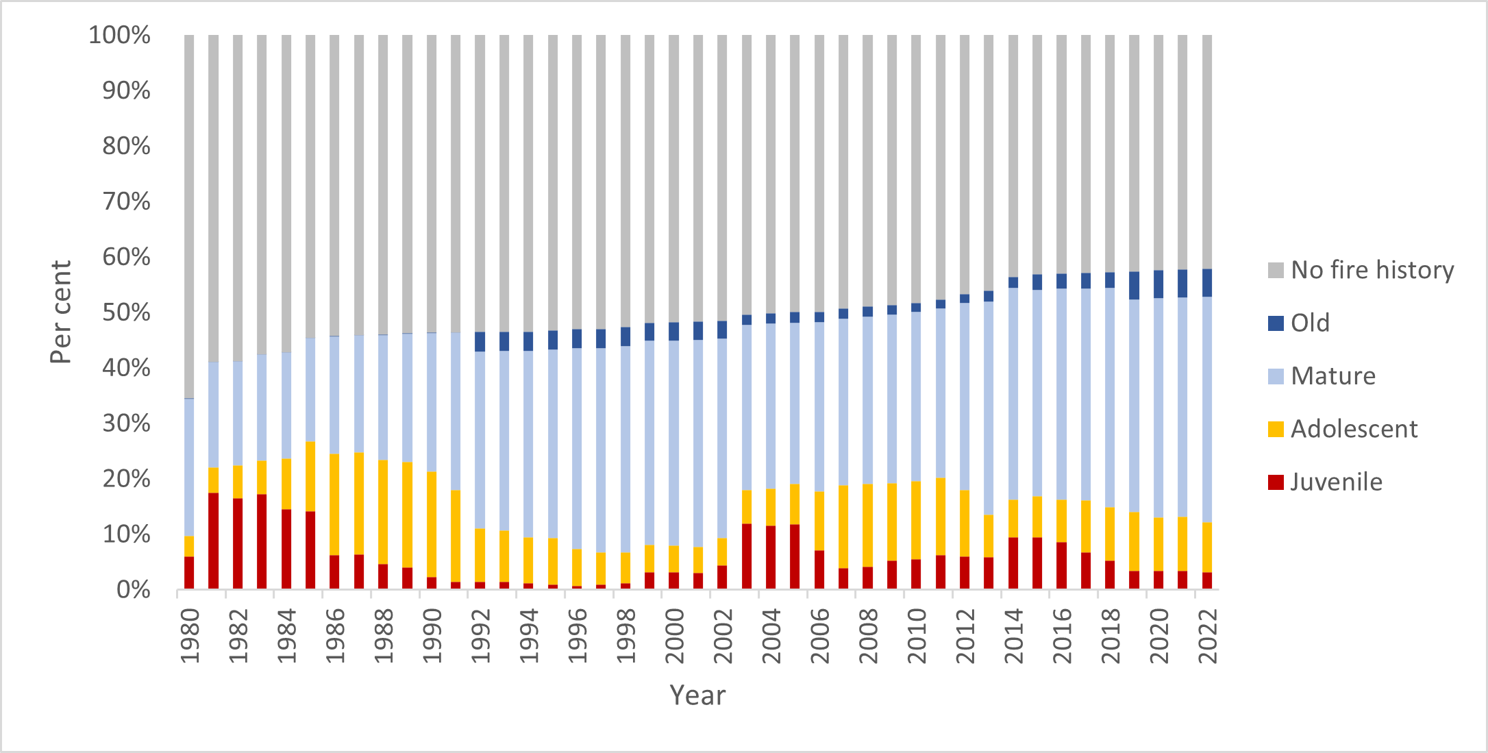
Figure 27 shows the growth stage structure (GSS) status of vegetation on public land in the Port Phillip region since 1980. It shows that in 2021–22:
- 12% of vegetation was in the juvenile growth stage, 4% lower than in 2020–21
- 30%of vegetation was in the adolescent growth stage, 4% higher than in 2020–21
- the proportion of vegetation in the mature growth stage remained stable at 43%
- the proportion of vegetation in the old growth stage remained stable at 2%
- the proportion of vegetation with no fire history remained stable at 12% since 2020–21 but has gradually declined over the past decade.
Threatened species, such as Leadbeater’s possum and smoky mouse, rely on vegetation in the mature and old growth stages for habitat, particularly features such as hollow-bearing trees and coarse woody debris. It will take a long time for the landscape to recover from bushfire to these growth stages, as some vegetation communities can take up to 50 years or more to reach maturity.
Figure 27: GSS status of vegetation on public land, Port Phillip region, 1980–2022. Data aligns with financial year.

Fuel management delivery
Weather conditions in Port Phillip created a challenging environment for FFMVic crews throughout the 2021–22 season, but there were some good opportunities for both Metropolitan and Yarra Districts to deliver on their planned burning programs.
During 2021–22, Port Phillip treated 3,743 hectares with planned burning. This included 8 cross-tenure burns delivered with the CFA. Fuel was reduced on an additional 1,925 hectares through non-burn fuel treatments. The total cost of the Port Phillip fuel management program was $11.2 million.
Table 17 summarises the region’s fuel management activities in 2021–22.
Table 17: Fuel management activities, Port Phillip region, 2021–22
| Fuel reduction | Number of treatments | Hectares |
|---|---|---|
|
Area treated by planned burning Ecological burns: 567 hectares (11 burns) Fuel reduction burns: 3,128 hectares (21 burns) Other burns: 48 hectares (13 burns) |
45 | 3,743 |
|
Area treated by non-burn fuel treatments Mechanical mulching: 803 hectares (13 treatments) Mechanical slashing or mowing: 1,122 hectares (115 treatments) Other methods: 0 hectares (0 treatments) |
128 | 1,925 |
| Total area treated to reduce fuel-driven bushfire risk | 173 | 5,668 |
Port Phillip region felt the effects of a La Niña this year, resulting in a shorter-than-usual planned burning window between unstable weather systems.
To deliver on the Joint Fuel Management Program, the region-maintained readiness despite the challenging weather, ready to respond to favourable conditions with little notice. The Yarra District focused on completing several priority planned burns in the Healesville, McMahons Creek, Gilderoy, Millgrove and Toolangi areas.
The Metropolitan District undertook important burns in Montrose, Ferny Creek, Warrandyte and Lysterfield, protecting communities in these areas.
The Port Phillip region also felt the impacts of multiple storm events in the Dandenong Ranges. This area suffered significant storm damage, which had a considerable impact on the planned burn program, as preparation became more complex, and crews were diverted to essential storm recovery works.
Updated