FFMVic approach to fuel management on public land
Under the Forests Act 1958, the Department of Energy, Environment and Climate Action (DEECA) is responsible for managing bushfire risk in State forests, national parks and other protected public land in Victoria. It does this through Forest Fire Management Victoria (FFMVic), which is led by DEECA and draws on partnership arrangements with Parks Victoria, VicForests and Melbourne Water to manage bushfire risk.
The Code of Practice for Bushfire Management on Public Land 2012 (The Code) specifies the objectives of fuel management and informs the planning and delivery of fuel management on public land.
A bushfire management strategy for each of DEECA’s six regions (Barwon South West, Grampians, Loddon Mallee, Hume, Gippsland and Port Phillip) informs fire management zoning which is a key tool to implement local bushfire management objectives.
Each fire management zone has its own intended fuel treatment aims and associated performance measures, although multiple goals can be achieved when undertaking activities in a zone.
The Code defines four fire management zones:
Asset Protection Zone (APZ)
Using intensive fuel treatment, the APZ aims to provide the highest level of localised protection to human life and property and key community assets. The goal of fuel treatment is to reduce radiant heat and ember attacks from a bushfire. Fuel treatments in the APZ include planned burning and non-burn fuel treatments (such as mowing, slashing, mulching and spraying).
Bushfire Moderation Zone (BMZ)
This zone aims to reduce the speed and intensity of bushfires. This zone complements the APZ, as planned burning in the BMZ aims to protect nearby assets, particularly from ember spotting during a bushfire. Where practicable, FFMVic aims to achieve ecological outcomes through ecologically desirable fire regimes, if bushfire protection objectives – including fuel reduction through non-burn fuel treatments – can be met.
Landscape Management Zone (LMZ)
Within this zone, planned burning is used for the three broad aims of:
- bushfire protection outcomes by reducing the overall fuel and bushfire hazard in the landscape
- ecological resilience through appropriate fire regimes, and
- management of the land for specific values, including forest regeneration and protection of water catchments at a landscape level.
Other fuel reduction methods are used within this zone as appropriate.
Planned Burning Exclusion Zone (PBEZ)
This zone excludes the use of planned burning, primarily in areas where the vegetation is intolerant to fire.
2021-22 FFMVic fuel management
Fuel management activities
In 2021–22, Victoria experienced a La Niña weather pattern, which resulted in cool, wet conditions through autumn. This limited FFMVic’s ability to deliver planned burns, particularly for areas in the east of Victoria, where planned burn sites were too wet for preparation works.
FFMVic responded to this by moving 1,600 firefighters and 240 support staff to priority risk-reduction areas of the state where planned burning remained viable. More than 13,000 shifts were worked by staff outside of their base location, to ensure continuation of the Joint Fuel Management Program (JFMP) delivery. CFA resources also assisted with the delivery of a number of FFMVic fuel management activities providing both personnel and equipment.
Table 2 provides a snapshot of FFMVic’s statewide outcomes and delivery for 2021-22. The year-round FFMVic fuel-driven bushfire risk reduction program treated 77,927 hectares, with 264 planned burns across 62,260 hectares and non-burn treatments across 15,667 hectares. The planned burns included significant risk-reducing burns across Narbethong, Cabbage Tree, Moggs Creek and the Wombat Forest.
Table 2. Performance snapshot of FFMVic Statewide outcomes and delivery, 2021-22.
| Performance measures | Unit of measure | 2021-22 Target | 2020-21 Actual | 2021-22 Actual | Projected actual in 2021-22, in the absence of bushfires and fuel management |
|---|---|---|---|---|---|
| Outcome: Statewide fuel-driven bushfire risk | % | 70 | 63 | 62 | 65 |
| Activity: Area treated with fuel management | ha | n/a | 152,083 | 77,297 | n/a |
| Activity: Cross-tenure burns | number | n/a | 37 | 32 | n/a |
| Activity: Strategic fuel breaks built or upgraded | km | 963 | 545 | 741.3 | n/a |
| Activity: Joint Fuel Management Plans completed | date | Sept 2021 | Sept 2020 | Oct 2021 | n/a |
| Outcome: Vegetation on public land within tolerable fire interval | % | n/a | 22' | 23 | - |
| Outcome: Vegetation on public land in the mature or old-growth stages | % | n/a | 36 | 37 | - |
| Activity: Traditional Owner led cultural burns supported | number | n/a | 15 | 13 | n/a |
| Investment: Total cost of FFMVic fuel management program | $M | n/a | 155.9 | 151.0 | n/a |
i: Note that data and modelling improvements led to some 2020-21 figures being recalculated. Vegetation on public land in the mature or old growth stages for 2020-21 was revised from 34% to 36%. Further information on these changes is provided in Appendix 1.
From 505 burns listed on the JFMP for 2021–22, FFMVic identified 135 priority planned burns, with the state and regions identifying which burns would reduce risk the most. This prioritisation focuses FFMVic efforts on the burns that deliver the greatest risk reduction when weather conditions that suit those areas are predicted. In 2021–22, this focus delivered 89 of the identified 135 priority burns (66%).
This year, FFMVic continued to partner with Traditional Owners to implement the Victorian Traditional Owner Cultural Fire Strategy. Over the season, five Traditional Owner groups across three regions (Loddon Mallee, Grampians and Barwon South West) led 13 cultural burns across 366 hectares with planning, delivery and post-fire management support from FFMVic.
The groups were the:
- Dja Dja Wurrung Aboriginal Corporation
- Barengi Gadjin Land Council
- Barapa Land and Water Corporation
- Gunditj Mirring Traditional Owners Aboriginal Corporation
- Wadawarrung Traditional Owners Aboriginal Corporation.
Through the support of a Cultural Fire Grants Program for Traditional Owners, it is projected that the number of cultural burns delivered throughout the state will increase in the coming years.
FFMVic also continued to put procedures in place to ensure COVID-19 risks were mitigated for staff and the community and recognised community concerns about how potentially increased levels of smoke from planned burning might affect businesses recovering from the impacts of COVID-19.
FFMVic worked closely with communities, stakeholders, and other government agencies – including the Environment Protection Authority and Department of Health – to minimise the impacts of planned burns on communities.
This included scheduling burns in weather conditions that minimised impact, or rescheduling burns to outside peak holiday times.
In addition to planned burning and non-burn fuel treatment activities, FFMVic also undertook a range of other activities that contributed to reducing bushfire risk, including:
- 741 kilometres of strategic fuel breaks built or upgraded across the state
- 6,696 kilometres of public land roads cleared of storm debris
- maintenance of tracks and roads, and
- management of hazardous trees to enable safe and rapid access for firefighting.
In 2021–22, no burning was done for regeneration purposes following timber harvesting.
Table 3 shows key statistics about FFMVic fuel management activities that kept fuel-driven bushfire risk below 70% for Victoria.
Table 3: Fuel-driven bushfire risk for Victoria at 30 June 2022.
Bushfire risk
| Measurement | Outcome |
|---|---|
| Statewide fuel-driven bushfire risk at or below | 70% |
| Fuel-driven bushfire risk for Victoria in 2021–22 | 62% |
Fuel management activities
| Treatment description | Size |
|---|---|
|
Area treated by planned burning By fire management zone:
By planned burn type:
|
62,260 hectares, 264 burns |
|
Area treated by non-burn fuel treatments By treatment types:
|
15,667 hectares, 1,785 treatments |
| Total area treated to reduce fuel-driven bushfire risk | 77,927 hectares |
Cultural fire
| Traditional Owner led cultural burns | |
| Cultural burns | 366 hectares, 13 burns |
* FFMVic is a land manager, with bushfire risk being one target, currently set at 70%. Bushfire management strategies outline the many outcomes of the fuel management program. Activities such as the number of burns and hectares planned for treatment are not targets but illustrate the scale of work funded to achieve the outcomes of bushfire management strategies.
Cross-tenure fuel management delivery
FFMVic’s fuel management program is strengthened by the Victorian Government’s Safer Together program, which ensures FFMVic works in partnership with CFA, Fire Rescue Victoria (FRV), the Department of Transport and Planning (DTP) and local government to support integrated, evidence-based bushfire risk management across all public and private land in Victoria.
In 2021–22, 32 cross-tenure planned burns were delivered by FFMVic and CFA, shown in Table 4, including on large areas of private land.
The majority of these burns were regionally critical due to being aligned to regional bushfire management strategies and providing high levels of risk reduction value. All cross-tenure planned burns are included in the fuel-driven bushfire risk calculations.
Table 4: Cross-tenure planned burns, by region, Victoria, 2021–22
| Region | Number of burns | Hectares |
|---|---|---|
| Barwon South West | 12 | 9,172 |
| Gippsland | 5 | 3,858 |
| Grampians | 6 | 1,031 |
| Hume | 1 | 2,693 |
| Loddon Mallee | 0 | 0 |
| Port Phillip | 8 | 227 |
| Total | 32 | 16,981 |
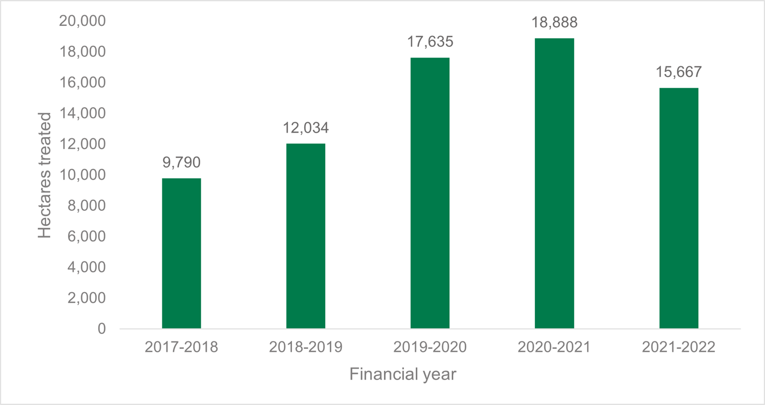
Figure 8 shows that FFMVic undertook mechanical fuel treatments across 15,667 hectares in 2021–22.
Figure 8: Comparison of total area treated by non-burn fuel treatments, Victoria, 2017–18 to 2021–22
Planned burn ignitions
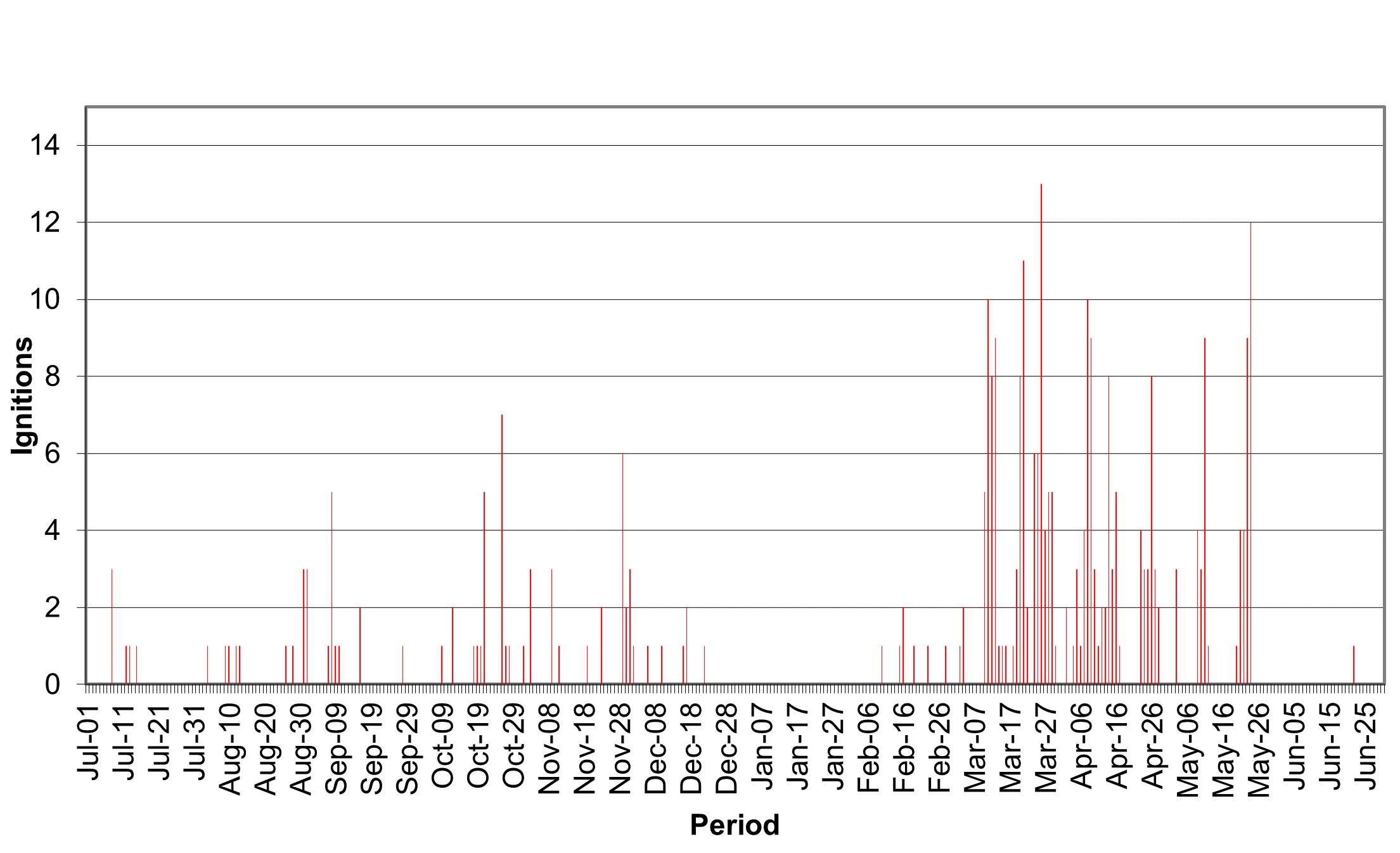
FFMVic continues to identify when conditions are favourable and takes every opportunity to complete planned burning, including during the winter months. Figure 9 shows the number of planned burns ignited each day across 2021–22. In some districts, La Niña’s impact resulted in shorter windows between the passing unstable weather systems for planned burning. Despite this impact, burns were ignited on 58 days in autumn, consistent with longer-term averages, demonstrating that opportunities continue to be taken where they exist.
Figure 9: Number of daily ignitions of planned burns, Victoria, 2021–22

The vast majority of the planned burning program continues to be delivered in the late summer and autumn when weather conditions are typically more stable, fire behaviour is generally more manageable and predictable, there is a lower risk of extreme fire danger days, and the fuel conditions are appropriate to achieve the desired burn objective.
Planned burn opportunities
In 2021, FFMVic released a prototype tool to track ignition opportunities on a day-by-day basis and record why individual burns were not ignited as originally planned. The tool does not report on Traditional Owner or heap burns, (small debris pile burns at point locations) so numbers in this section will differ slightly from figures stated elsewhere in the report. This tool provides data from the beginning of the 2021-22 financial year.
In 2021–22, FFMVic planned to deliver 505 burns as a part of Year 1 of the JFMP. Another 22 burns were brought forward from Year 2 and Year 3 to take advantage of suitable opportunities. Of these burns:
- 194 (38%) of Year 1 burns were delivered
- all of Year 2 and Year 3 burns brought forward to 2021-22 were delivered, bringing the annual total to 216 burns delivered (does not include Traditional Owner cultural burns or heap burns)
- 311 (62%) of Year 1 burns were not delivered as intended, with 61 (20%) of those burns scheduled but not ignited.
Table 5 shows factors influencing the 311 planned burns on Year 1 of the JFMP that were not delivered.
Table 6 shows factors influencing the delivery of the 61 burns that were scheduled but not ignited.
Table 5, Factors influencing the delivery of planned burns not ignited, Victoria 2021–22
| Factors influencing delivery | Proportion (%) |
|---|---|
| Weather conditions not suitable | 52.7% |
| Fuel moisture not suitable | 18.9% |
| Burn planning or burn preparation not completed in time | 26.2% |
| Resources unavailable | 1.0% |
| Community or stakeholder related | 0.6% |
| Other | 0.5% |
Table 6: Factors influencing the delivery of planned burns scheduled but not ignited Victoria, 2021–22
| Factors influencing delivery | Proportion (%) |
|---|---|
| Fuel moisture not suitable | 27.8% |
| Weather conditions not suitable | 27.2% |
| Resources unavailable | 7% |
| Re-prioritised | 1.9% |
| Environment, community, stakeholder related | 1.2% |
| Other constraints | 5.1% |
| Removed from schedule, reason not specified1 | 29.8% |
1 Planned burns removed from schedule without a reason being provided. Future improvements to the tracking tool will require a reason to be entered for burns removed from the schedule.
In 2021-22, 311 burns (62%) in Year 1 of the Joint Fuel Management Program were not delivered as intended.
In most cases, burns were not scheduled or were cancelled because:
- weather conditions were unsuitable
- the weather forecast changed, or
- fuels (vegetation) were either too wet or too dry to meet the objectives of the burn.
For 81 of the 311 burns (26.2%) which were not ignited, burn planning or site preparation works had not been completed.
Various activities need to be completed for a burn to be considered fully planned and prepared, including things that can take time, such as checking the values within a burn unit, notifying neighbouring landholders and holding community consultation activities.
Significant rainfall and average to cooler-than-average conditions across much of the state impacted FFMVic’s ability to prepare and deliver burns on Year 1 of the JFMP, particularly in areas where planned burn sites were too wet for preparation works or subject to storm damage, such as in the Wombat State Forest and Dandenong Ranges.
Burns scheduled for 2021–22 delivery was not fully planned and prepared if conditions indicated low confidence of suitable weather and forest conditions for delivery. Instead, burns scheduled for future years were brought forward.
This ability to adapt to variable conditions across the state is an important aspect of FFMVic’s bushfire risk reduction program.
Learnings from the Ignition Tool prototype
The Ignition Tool also showed that in 2021–22, resource availability was a moderate issue that occurred mostly in the Barwon South West region, where the level of burning was high compared with other regions.
Where burning activity is high, local resource availability becomes constrained, and resources are brought in from areas of the state that have fewer opportunities to deliver priority planned burns.
Despite this movement of resources, shortfalls can still be experienced, because the correct burning conditions are often right for many burns at the same time.
As a result, FFMVic prioritises allocation of resources to the priority burns that will achieve the greatest risk reduction. The sustained burn windows in Barwon South West also required careful management of operational fatigue.
FFMVic has indicated it will continue to improve the information captured in relation to burn planning, scheduling and operational delivery in 2022–23.
Traditional Owner-led cultural burning
DEECA is committed to reconciliation and a Treaty for Victoria’s Traditional Owners. In response to the needs of Traditional Owners and Aboriginal Victorians, DEECA developed Pupangarli Marnmarnepu 'Owning Our Future’ Aboriginal Self-Determination Reform Strategy 2020-2025 (the Strategy).
The Strategy is a five-year roadmap that enables self-determination at DEECA by fostering an environment that honours the rights and dignity of Traditional Owners and Aboriginal Victorians.
The Strategy is founded on cultural authority that sets the strategic direction and actions for us to advance Aboriginal self-determination.
FFMVic acknowledges the diversity of ways Traditional Owner groups want to use cultural fire and participate in land management.
FFMVic continues to build partnerships with Traditional Owner groups to deliver cultural burning on public land, build capacity through the Cultural Fire Grants Program, and provide operational support for the implementation of the Victorian Traditional Owner Cultural Fire Strategy.
During 2021–22, FFMVic provided operational and planning support to Traditional Owner groups across Victoria to plan and undertake 13 cultural burns. These were additional to planned burning for bushfire risk management purposes.
While cultural burns may reduce fuel-driven bushfire risk (and are included in risk calculations), the objectives of cultural burns are varied and are defined by the Traditional Owners leading the burn.
Table 7 shows the total area and number of Traditional Owner cultural burns completed in 2021–22.
Traditional Owners have a strong interest in burning, and there is an expectation the number of cultural burns will continue to increase in 2022–23.
Table 7: Traditional Owner cultural burns, by region, 2021–22.
| Region | Number of burns | Hectares |
|---|---|---|
| Barwon South West | 3 | 95 |
| Gippsland | 0 | 0 |
| Grampians | 5 | 62 |
| Hume | 0 | 0 |
| Loddon Mallee | 5 | 209 |
| Port Phillip | 0 | 0 |
| Total | 13 | 366 |
Fuel management investment
FFMVic invested $151.0 million on fuel management in 2021–22, a 3% decrease from $155.9 million in 2020–21.
Table 8 provides a breakdown of this investment by region and type of investment.
Direct investment totalled $37.3 million, with indirect investment totalling $113.7 million.
Table 9 provides a further breakdown of indirect investment.
A large proportion of the indirect fuel management costs are associated with resource management (42%) and equipment and infrastructure (16%) costs.
Appendix 1 summarises year-on-year costs.
Table 8: Fuel management investment, by region and group, Victoria, 2021–22
| Region | Fuel management $ (direct) | Fuel management $ (indirect) | Total ($) |
|---|---|---|---|
| Barwon South West | 9,498,735 | 8,410,795 | 17,909,530 |
| Gippsland | 4,464,226 | 17,810,783 | 22,275,009 |
| Grampians | 4,749,695 | 8,215,953 | 12,965,648 |
| Hume | 7,538,986 | 17,129,979 | 24,668,965 |
| Loddon Mallee | 2,850,209 | 8,724,855 | 11,575,064 |
| Port Phillip | 5,117,731 | 6,125,340 | 11,243,071 |
| Statewide | 3,032,264 | 47,311,791 | 50,344,056 |
| Total fuel management investment | 37,251,846 | 113,729,496 | 150,981,343 |
Table 9: Indirect fuel management investment, by items, Victoria 2021–22
| Item | Indirect investment (%) | Total ($) |
|---|---|---|
| Business management | 5 | 5,507,634 |
| Capability | 11 | 12,247,137 |
| Engagement | 6 | 7,352,872 |
| Equipment and infrastructure | 16 | 18,378,101 |
| Monitoring, evaluation, and reporting | 7 | 7,864,637 |
| Native vegetation framework | 0 | 30,142 |
| Operational planning | 5 | 5,400,420 |
| Research | 1 | 1,286,836 |
| Resource management | 42 | 48,750,136 |
| Strategic planning | 6 | 6,911,581 |
| Total indirect investment | 100 | 113,729,496 |
Victorian Bushfire Monitoring Program
In 2021–22, the Monitoring, Evaluation and Reporting Framework for Bushfire Management on Public Land (PDF, 1.32 MB) continued to be delivered through the Victorian Bushfire Monitoring Program (VBMP).
This included monitoring fuel levels, ecosystem resilience measures, research projects and location-specific activities to support improvement.
The data from monitoring enables FFMVic to understand how effectively planned burning reduces bushfire fuels and to evaluate performance in reducing fuel-driven bushfire risk.
Fuel hazard monitoring
Fuel hazard monitoring provides important information about:
- planned burns, including the severity and coverage of each burn
- how each planned burn has reduced fuel hazard
- the success of each planned burn in achieving ecological burn objectives, where appropriate, and
- whether follow-up actions are required.
Burn objectives are set to achieve a balance between fuel reduction and preserving important values. For example, a burn objective may be to achieve 70% burn coverage within the footprint of a planned burn to ensure that sufficient refugia, habitat and food sources are left for flora and fauna.
When evaluating a planned burn, a series of plots are measured. In some instances, these are in areas intentionally left unburnt to provide refuge for animals in the planned burn area.
Table 10 shows the overall fuel hazard monitoring effort for 2021–22.
Table 10: Fuel hazard sites monitored, by region, Victoria, 2021–22
| Region | Number of pre-burn sites | Number of post-burn sites | Other | Total |
|---|---|---|---|---|
| Barwon South West | 421 1 | 358 1 | 0 | 779 |
| Gippsland | 83 | 71 | 400 2 | 554 |
| Grampians | 401 | 201 | 0 | 602 |
| Hume | 314 | 130 | 0 | 444 |
| Loddon Mallee | 50 | 50 | 0 | 100 |
| Port Phillip | 109 | 37 | 0 | 146 |
| Statewide | 957 | 847 | 400 | 2,625 |
1 This includes 100 monitoring points captured by the Conservation Ecology Centre as part of a collaborative research project.
2 This includes 200 permanent monitoring sites located in Asset Protection Zones in Gippsland. These sites are monitored whether they are burnt or not. Of these sites, 54 were in the Black Summer fire area.
Additional monitoring and improvement activities
In 2021–22, FFMVic continued to deliver the statewide ecosystem resilience monitoring program in partnership with Natural Hazards Research Australia (previously the Bushfire Natural Hazards Cooperative Research Centre), La Trobe University, Deakin University and the University of Melbourne.
To date, DEECA has invested more than $5.6 million in this monitoring, which is collecting data on habitat structure, flora, birds and mammals in 11 priority ecological fire groups across the state.
Victoria now has data for three of the highest-priority ecological fire groups, providing opportunities to replace expert datasets with empirically derived data in models and decision-making.
Data collection is underway in the remaining eight ecological fire groups.
This monitoring program is providing scientific evidence and recommendations for fire management and planning, improving the ecological basis underpinning Victoria’s ecosystem resilience metrics and future monitoring and research.
Table 11 shows additional VBMP activities undertaken across the state in 2021–22.
Table 11: Monitoring and improvement activities are undertaken, at a Statewide level and by region, Victoria, 2021–22
| Region | Monitoring activities |
|---|---|
| Statewide |
|
| Barwon South West |
|
| Gippsland |
|
| Grampians |
|
| Hume |
|
| Loddon Mallee |
|
| Port Phillip |
|
Updated