The Public Transport Data Program is releasing better accessibility information to the open data community.
This will help provide improved travel information and options for all users so they can confidently plan their journeys, regardless of ability level or journey planning tool they use.
The open data community includes application providers but also allows for research and innovation. Improvements are being made through a range of projects:
Updated public transport network information for the open data community
Public transport network information including vital accessibility features will be mapped and made available in the open data market.
Improved accessibility information and digital navigation
- More detailed information about accessible features and facilities will be mapped, with locations of lifts and ramps, entrances and exits, and footpaths and walkways.
- Facilitate smoother interchanges between different transport modes.
- Support journey planning by considering the time required to walk between essential features such as platforms, entry/exit points, car parks and drop-off zones.
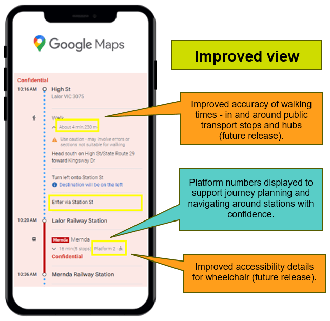
Improved accuracy of walking times
Walking times in and around public transport stops and hubs will be mapped to provide more accurate information that will help users with mobility needs to:
- Facilitate smoother interchanges between different transport modes.
- Support journey planning by considering the time required to walk between essential features such as platforms, entry/exit points, car parks and drop-off zones.
Improved timetable data and transfer information
Timetable trip data will be enriched to incorporate additional accessibility details, including:
- Improved accessibility details for wheelchair users.
- Improved tram accessibility information in PTV journey planning app.
Improved accessible trip information
- Third-party journey planning tools will have more consistent and accurate accessibility information enabling users of all abilities to better plan and navigate their journeys seamlessly.
Improved real-time and disruptions information
The new systems, processes and data feeds needed to provide real-time public transport information for all modes will be set up and made available in the open data market.
This will support better accessibility outcomes by setting the foundations to expand real-time data to include status updates on key accessibility features such as when a lift or escalator is out of order and when it is up-and-running again.
Updated