Victoria government logo

Research permits

Researchers seeking to conduct research on Victoria’s flora and fauna may require a permit.

Permits to conduct scientific research may be required under the following acts:

  • Wildlife Act 1975
  • Flora and Fauna Guarantee Act 1988
  • Reference Areas Act 1978
  • Forests Act 1958

Research conducted on public land managed by Parks Victoria may also require an access agreement from Parks Victoria.

Pre-application checklist

To determine what permits or permissions may be required, a simple online tool has been developed to assist research planning.

The checklist takes approximately 3 to 5 minutes to complete. A copy of the results can be emailed to you for your records.

Access the pre-application checklist.External Link

Guidance notes for research permit applicants

Guidance notes have been developed to help researchers understand and complete the research permit application process. Applicants are encouraged to read these notes prior to submitting an application or contacting the Conservation Regulator for further information.

Research Permit Applications

A research permit is required for research activities which involve:

  • activities where wildlife will be disturbed, captured, marked, translocated, kept, sampled, or destroyed
  • protected fish, freshwater crayfish, or aquatic invertebrates
  • protected or threatened flora.
  • Any activities where wildlife will be disturbed, captured, marked, translocated, kept, sampled or destroyed for research purposes requires a permit under the Wildlife Act 1975.

    Animal welfare and animal ethics approvals

    Some wildlife research may also require approval Animal Ethics Committee approval to meet requirements under the Prevention of Cruelty to Animals Act 1986 or any other relevant legislation. For more information on animal ethics approvals visit Agriculture VictoriaExternal Link .

    Researchers must comply with all requirements of the Australian Animal Welfare Standards Code of PracticeExternal Link .

    Where animal ethics approval is required, applicants must include both a copy of the animal ethics application and approval from an Animal Ethics Committee.

    For any scientific research involving wildlife, including holding wildlife in captivity, please use the 'Apply now for a research permit' button below.

  • Permits are required for activities that impact protected fish under the Flora and Fauna Guarantee Act 1988.

    For any scientific research involving protected fish, freshwater crayfish or aquatic invertebrates, please use the 'Apply now for a research permit' button below.

    Approval may also be required under the Fisheries Act 1995. For more information visit Victorian Fisheries AuthorityExternal Link .

    For more information about species protected under the Flora and Fauna Guarantee Act visit the DELWP websiteExternal Link .

  • Permits are required for activities that impact protected and threatened flora listed under the Flora and Fauna Guarantee Act 1988. A permit is required for activities involving the disturbance and/or taking of protected and threatened flora for research purposes.

    Flora includes fungi and lichen listed under the Flora and Fauna Guarantee Act 1988.

    For any scientific research involving protected and/or threatened flora, please use the 'Apply now for a research permit' button below.

    Contact your local DELWP regional officeExternal Link if you need to:

    • remove native flora on public land for construction purposes
    • remove grasstrees, tree-ferns and sphagnum moss from private property

    For more information visit the DELWP websiteExternal Link .

Apply now for a research permit

Education and Management Applications

An education and management permit is required for any activities which involve:

  • activities where wildlife will be disturbed, captured, marked, translocated, kept, sampled, or destroyed
  • protected fish, freshwater crayfish, or aquatic invertebrates
  • protected or threatened flora.
  • Any activities where wildlife will be disturbed, captured, marked, translocated, kept, sampled or destroyed for education or management purposes requires a permit under the Wildlife Act 1975.

    For wildlife activities for education or management purposes, please use the 'Apply now for an Education and Management permit' button below.

    Animal welfare and animal ethics approvals

    Some wildlife research may also require approval Animal Ethics Committee approval to meet requirements under the Prevention of Cruelty to Animals Act 1986 or any other relevant legislation. For more information on animal ethics approvals visit Agriculture VictoriaExternal Link .

    Researchers must comply with all requirements of the Australian Animal Welfare Standards Code of PracticeExternal Link .

    Where animal ethics approval is required, applicants must include both a copy of the animal ethics application and approval from an Animal Ethics Committee.

  • Permits are required for activities that impact protected fish under the Flora and Fauna Guarantee Act 1988.

    For education or management activities involving protected fish, freshwater crayfish or aquatic invertebrates, please use the 'Apply now for an Education and Management permit' button below.

    Approval may also be required under the Fisheries Act 1995. For more information visit Victorian Fisheries AuthorityExternal Link .

    For more information about species protected under the Flora and Fauna Guarantee Act visit the DELWP websiteExternal Link .

  • Permits are required for activities that impact protected and threatened flora listed under the Flora and Fauna Guarantee Act 1988. A permit is required for activities involving the disturbance and/or taking of protected and threatened flora for education, nursery propagation, and re-vegetation purposes.

    Flora includes fungi and lichen listed under the Flora and Fauna Guarantee Act 1988.

    For education or management activities involving protected or threatened flora, please use the 'Apply now for an Education and Management permit' button below.

    Contact your local DELWP regional officeExternal Link if you need to:

    • remove native flora on public land for construction purposes
    • remove grasstrees, tree-ferns and sphagnum moss from private property

    For more information visit the DELWP websiteExternal Link .

Apply now for an Education and Management permit

Research on land managed by Parks Victoria

Research permits are no longer issued under the National Parks Act 1975. For research in parks and waterways managed by Parks Victoria, researchers can apply for an Access AgreementExternal Link .

Research activities being conducted on Parks Victoria managed land may also require a permit under the Wildlife Act 1975 or Flora and Fauna Guarantee Act 1988. Using the pre-application checklistExternal Link will help you determine whether you need to apply for a permit.

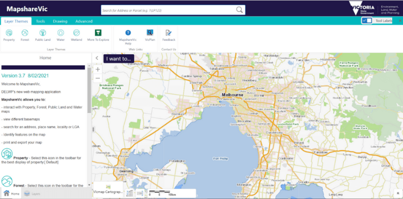
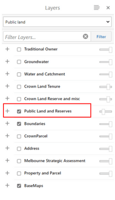
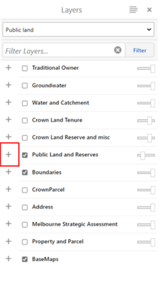
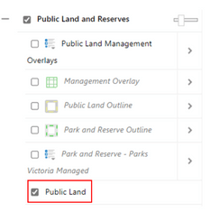
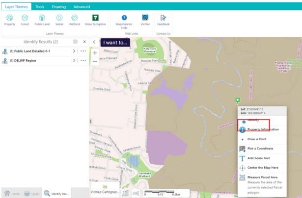
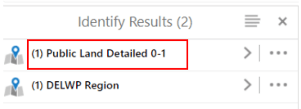
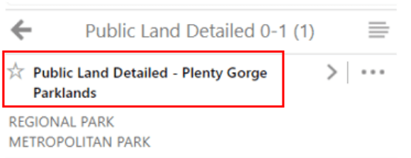
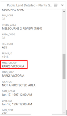
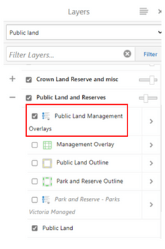
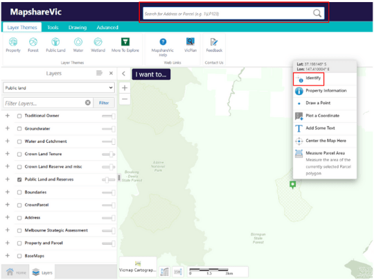
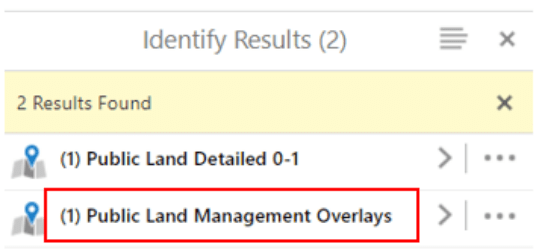
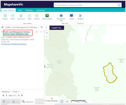
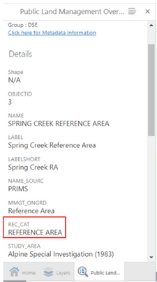
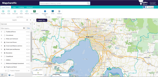
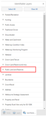
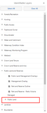
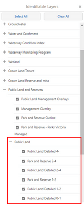
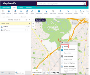
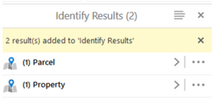
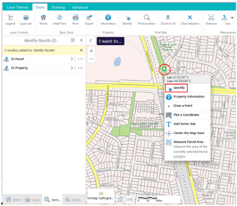
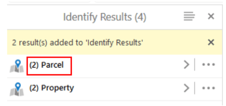
How do I work out who manages the public land I propose to work on?

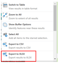
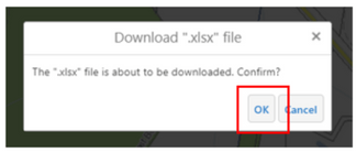
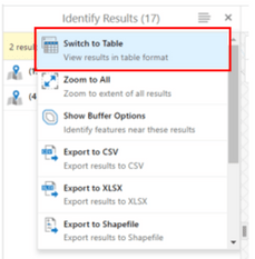
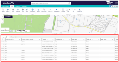
The relevant land manager of public land in Victoria can be found on MapShareVicExternal Link using the instructions attached below.

Map Share Instructions

  • This guide provides simple step by step instructions to use MapShareVic.

    Researchers can use the MapShareVic tool to determine the relevant public land manager.

    Some research activities on public land may require permission from the relevant land manager prior to undertaking any approved research activities, even if a permit under the Wildlife Act 1975 or the Flora and Fauna Guarantee Act 1988 has been issued.

    1. Start from the MapshareVic Home PageExternal Link and set up the correct spatial layers following Steps 2 to 5.
    2. Select the Layer Themes tab, and click on ‘Public Land’.
    3. A drop-down menu will appear on the left-hand side of the map. Untick all boxes except ‘Public Land and Reserves’. (‘Boundaries’ and ‘BaseMaps’ can be ticked, as these only provide geographical references and won’t impact the results generated).
    4. Expand the ‘Public Land and Reserves’ layer by clicking on the ‘+’ sign.
    5. Ensure only ‘Public Land’ is ticked.
    6. Find the desired land parcel on the map by typing the park or reserve name in the search box. This will automatically focus the map on the area selected. Alternatively, use the cursor to manually move the map until you located the desired area. Right-click the desired land parcel. This action will drop a pin and open a menu on the map. From this menu, click on ‘Identify’.
    7. A drop-down menu will appear to the left of the map. Click on ‘Public Land Detailed 0-1’.
    8. Click on the name of the selected land parcel.
    9. To identify the land manager of the area selected, scroll down to the heading ‘MNG_GROUP’ on the menu to the left of the map.

    End of Instructions

  • Reference Areas are areas of public land that have been established under the Reference Areas Act 1978 (Vic). Reference Areas include typical examples of land types that have not been modified for productive uses such as agriculture, mining or timber production in the past.

    Please note that additional requirements apply when conducting research within Reference Areas. For further information please contact environmental.research@delwp.vic.gov.au.

    1. Start from the MapshareVic Home PageExternal Link and set up the correct layers following steps 2 to 5.
    2. Select the ‘Layer Themes’ tab, and click on ‘Public Land’.
    3. A drop-down menu will appear on the left-hand side of the map. Ensure the layer ‘Public Land and Reserves’ is ticked.
    4. Expand the layer ‘Public Land and Reserves’ by clicking on the ‘+’ sign.
    5. Ensure ‘Public Land Management Overlays’ is ticked. This is the overlay that will show Reference Areas on the map. MapShare is now correctly set up to display information on Reference Areas.
    6. Find the desired land parcel on the map by typing the park or reserve name in the search box. This will automatically focus the map on the area selected. Alternatively, use the cursor to manually move the map until you located the desired area. Right-click the desired land parcel. This action will drop a pin and open a menu on the map. From this menu, click on ‘Identify’.
    7. A menu will open on the left-hand side of the map. Click on ‘Public Land Management Overlays’. Please note that if the menu only displays the option ‘Public Land Detailed’ and not the option ‘Public Land Management Overlays’ as shown in the image below, the land parcel selected is not a Reference Area.
    8. Click on the name of the selected land parcel.
    9. To verify that the land parcel is a Reference Area, scroll down to the heading ‘REC_CAT’ on the menu to the left of the map.

    End of Instructions

    1. Start from the MapshareVic Home PageExternal Link and set up the correct layers following steps 2 to 5.
    2. Select the ‘Tools’ tab, and click on ‘Identify’.
    3. Click on ‘Enable Add Results’, then on ‘Identifiable Layers’.
    4. A menu will open on the left-hand side of the map. Expand the layer ‘Public Land and Reserves’ by clicking on the ‘+’ sign next to it.
    5. The menu will expand to reveal more options. Expand the ‘Public Land’ layer by clicking the ‘+’ sign next to it.
    6. The menu will expand to reveal more options. Ensure all boxes in the ‘Public Land’ layer are ticked. You are now ready to select and identify multiple land parcels.
    7. Find the desired land parcel on the map by typing the park or reserve name in the search box. This will automatically focus the map on the area selected. Alternatively, use the cursor to manually move the map until you locate the desired area. Right-click the desired land parcel. This action will drop a pin and open a menu on the map. From this menu, click on ‘Identify’.
    8. A menu on the left-hand side of the map will open and show a summary of land parcel(s) selected and identified.
    9. Repeat Step 7 for each land parcel you want to select. You must hit the 'identify' button between each land parcel you select.
    10. After a new land parcel is identified, the menu on the left updates with new information.
    11. Once you have selected all land parcels, click the symbol with four grey lines from the menu.
    12. A menu will open on the left-hand side of the map. Click on Export to XLSX.
    13. A pop-up window will open and ask to confirm the download of the Excel file containing information on all land parcels selected. Click ‘Ok’ to being the download.
    14. To view a summary of all selected land parcels, click on ‘Switch to Table’ at Step 12.
    15. This will change view to show information on all selected parcels in a table at the bottom of the map.

    End of Instructions

PDF Application Forms

Reviewed 22 August 2022

Contact us

Was this page helpful?